

One and a thousand Sahara
The Sahara is a great desert. In every sense it is enormous: it is the largest desert in the world, the hottest, the driest... To get into it you have to be very brave. The best thing is to go in caravan. In order to enter the territory of thirst, this is called the areas away from wells and oasis, better in group.
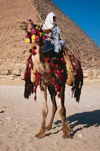
The caravan has been the most frequent and safe form of transport in the desert. I know how many slaves, gold and luxury themes have crossed the Sahara caravan. It has always been the basis of trade. And commerce is very old in the desert.
First large caravans VIII. Historians believe that they were around the twentieth century. But it is not clear when the trade routes were opened in the Sahara, since the footprints are scarce. For example, some of the decorative elements found in sub-Saharan cities have been made with copper from Moroccan mines. Depending on the dating, these decorations go to C. They correspond to the year 400. And they are also written from that time. The Roman herodote, for example, made an expedition in the desert with the help of the Berbers and described, among other things, trade among several human groups.
The commercial tradition is very important in the Sahara and in all its surroundings. They say that formerly they formed caravans of twelve thousand camels. And by the way, the camel itself came to the Sahara thanks to trade. In fact, it is not of origin, but of Arabia. A. A. C. C. VI. It was introduced in Egypt in the twentieth century, but in C. III. Until the twentieth century it was not extended to all the Sahara. But those big camel caravans are old. Trade has suffered a decline and, at present, caravans are smaller and smaller. And little by little the camel caravan has been replaced by the cargo truck.
More than live sand and broth
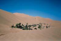
In any case, the means used by desert nomads for both trade and displacement are the same as those used in the last thousands of years. The highways of higher traffic are called desert highways. These roads cross the desert from one side to the other, from an oasis or well to another. In these places, the trader, the traveler or the nomad have the opportunity to drink water and rest.
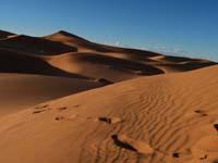
Recreational and road area Oasia de arena. The landscape that comes to mind when you imagine a caravan is an endless territory covered with sand. But in reality the landscape is richer. There are very different geomorphological structures in the Sahara: mountainous lines such as Atlas, Tibesti and Ahaggar, dry river basins, shallow lakes, rocky reg plains, sand dunes erg, plateaus... And it is that names like erg, reg and hammada have their origin in the Sahara.
The erg and reg are the most well-known structures of the desert. They originate by the action of the wind and water and come from the so-called hammadas, rocky plateaus around the naked port by erosion. When there is intense rain (typical of the desert), the water extends through the plain through the slits. The flood drags stones and mud into the lower territories, giving rise to the regs, an almost flat area of stone.
As the watering erodes, especially due to the wind, sand breaks out. This sand is easily transported by the wind and accumulated in closed depressions. The ancient activity has been accumulating sand forming large areas of sandy dunes, erg. The largest erg of the Sahara is the desert of Libya -- climbed to the top of a dune, it seems that this sea of sand has no end.
Territory of contrasts
For the desert of Libya is the warmest place in the world. The highest temperature in history has been measured in the erg of Libya, specifically in Azizija: 58ºC in the shadows. In general, the average daily temperature in the Sahara exceeds 30ºC. At night, however, the temperature drops a lot, especially in winter. Nothing else hide the sun the earth begins to lose heat, and since there are no clouds in the sky to retain that heat, there are also temperatures under zero. This thermal incidence is not of prank. The incidence has been thirty-eight degrees in a few hours (-0.5 °C per night and 37.5 °C per day).
However, the climate is not homogeneous throughout the Sahara desert, and two climatic zones are usually differentiated. Thus, in the south it is said that the climate is tropical dry and in the north, subtropical dry. This differentiation is mainly due to temperature and rainfall. The north is very dry. In the South, however, it rains more often: The Sahel is a territory of transition between the desert and the savannah.
Unlike Sabana, in the Sahara there is not a clean rainy season and in general it rains little. Due to its location and orography, the rain clouds are scarce. From southern Africa, by the so-called intercontinental convergence, it reaches a little south of the Sahara. The Northern Sahara has a greater drawback: The Atlas serve as a barrier to clouds from the ocean. Thus, it is very difficult for clouds to reach the center of the desert. That is why it is the driest territory. Years can pass without dripping and the annual average ranges from 0 to 25 mm.
Despite the scarce rains, it is believed that in almost the entire desert bottom there is water. This water reaches the surface in certain areas and thanks to it, for example, there are oasis. However, in the middle zone of the Sahara are abundant the vast territories without water, called tanezfouft, which are the territories of thirst.
From abundant savannah to arid zone
The Sahara is, without a doubt, a dry territory. But it has not always been so. This climate is only five thousand years old. In the last ice season, for example, much of the Sahara was a savannah ventresca, most of which today are famed. Human groups left testimony of this richness. In the petroglyphs of Tassili n'Ajjer of Algeria you can see images of crocodiles, large groups of giraffes and other animals that usually live in rivers and savannahs.
The present Sahara is far from the prosperity represented by those prehistoric men and women. The land is arid, with very little organic matter and scarcity of rain. Therefore, there are few people who live. Outside the Nile basin, it lives approximately 0.4 people per square kilometer. People do not live scattered throughout the desert. It accumulates in places where there is water, especially in the surroundings of rivers and oasis.
They say that the human being has had something to do with the scarcity of water and that the earth is not productive, not only by the incidence of climate. It has exploited too much aquifers, the irrigation of the centuries has salted the lands and the livestock has eaten plants. This has meant the expansion of the desert. Many believe that the Sahara has reached the south of Spain. Will you arrive in Euskal Herria?
Zu idazle
Zientzia aldizkaria

