

Good or bad environment? That is the question
Meteorology is a science that studies atmospheric phenomena, and the work of the meteorologist is to predict the time it will perform in a certain place from thermodynamics and hydrodynamics. Throughout the day you only have to see the number of times the weather is mentioned to see which people are interested in the information offered by the meteorologist. In the words of the head of the Biarritz weather station, Mr. Laffite, "most people call Biarritz station to make weekend plans. There are also tourist offices and hotels that pay daily to receive this information." The main user of weather data is therefore the general public, but it is also useful for aeronautics, agriculture and fishing, as evidenced by its relationship with Biarritz airport and Irulegi wine producers.
... In fact, for the daily activities of airports it is evident that it is essential to know detailed information about wind and vision. But in addition to this information, they are also informed of humidity, among other things because if the air is humid, the ascending force of the Archimedes principle will help to take off the plane. This will allow the plane to load more. This time information is paid by airports, so aircraft landing are charged a special tax.
In agriculture it is also important to know weather information. Biarritz Station offers information to Irulegi wine producers, among others. In fact, a fungus that appears in the vine occurs only at certain conditions of humidity and temperature, this information being essential for a correct treatment.
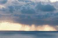
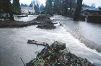
On the other hand, although in our environment there are no major misfortunes due to the storm, in many places it is important to predict strong winds and dangerous storms. An estimated 250,000 people die each year from natural disasters of meteorological or hydrological origin. The collaboration of meteorologists depends on the dynamic, thermal and hygrometric state of the atmospheric fluid surrounding the site and the weather. In short, predicting time is to determine previously the status of some homogeneous elements that vary depending on pressure, temperature, humidity and wind. To do this, each country has its own meteorological network.
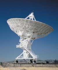
However, although each country coordinates and manages its meteorological network, the weather knows no political and economic borders, so the meteorologist must work over all borders. Therefore, it is essential that all measurements are carried out under the same conditions and that there is a global network of information exchange. According to the head of the Biarritz weather station, Laffite, "the weather network has been one of the first communication networks worldwide. All weather information used on this network is encrypted and these codes are translated into all languages."
This collaboration began in 1873 in Vienna with the creation of the International Meteorological Organization. It was not born as a government organization, but after a long history, in 1950, it became an intergovernmental organization. It was then called the World Meteorological Organization (WMO) and the following year it was appointed a specialized agency of the United Nations. The collaboration began with the organization MNE, but it was in XX. Thanks to the technological advances of the twentieth century has increased.
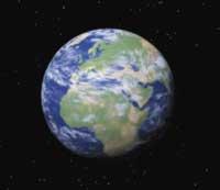
Thus, since 1996 there has been an international meteorological network consisting of five geostationary satellites (two Americans, the European Meteosat, one Japanese and one Russian). These satellites are located 36,000 km from the equator and each occupy a third of the earth.
The images and information offered by these satellites are necessary to know the time in each place, but digital simulation is done through mathematical models. Each country has its own mathematical model, but the most widely used are those in Central Europe, Germany, Canada, the United States, France, Japan and the United Kingdom.
French digital model
Today weather is largely done with the software that digital simulations of the atmosphere perform. The model used in the French state, called Arpège, was launched in 1993 and issues daily two forecasts.
The first thing this model does is to divide the atmosphere into small squares. The main advance of this system is the possibility to modify the resolution, that is, the size of the small boxes. Thus, to have a great precision, in the French State work at a resolution of 20 km and in the antipodes at 250 km. In addition, for example, if the existence of a war wants to obtain greater accuracy than usual in a certain region, the resolution can be adapted. Then, from the information received via satellite at that time, the different evolutions that each point can have are calculated. These evolutions are achieved by slightly modifying the initial conditions. The meteorologist remains to identify the most likely route and, of course, is based on his experience.
All this information is collected in Toulouse, France, and only the information you are interested in reaches each of the centers of the meteorological network. Once this information is obtained, in the center of Biarritz, taking into account the relief of the Basque Country and the influence of the sea, they announce more accurately the weather. Despite being a good example for large-scale work, it lacks precision to work at the Euskal Herria scale. For example, for the model, Larrun has a relief of between 100 and 200 meters and actually has about 900 meters. Mr. Laffite stressed that "in the Basque Country there are important contrasts due, on the one hand, to the influence of the sea and, on the other, to the importance of the relief".
At the moment, although technological advances have been spectacular, to make meteorological predictions it is essential to take into account the knowledge of meteorologists
Zu idazle
Zientzia aldizkaria

