

Geodiversity or value of the earth
In the Basque Country, the K/T border can be seen in several places. However, before it was present in more places. Some of them have been eliminated, in most cases in infrastructure works such as a tunnel (variant of Herrera), a car park (port of Pasaia) or simply a wall (Loreto de San Sebastián).
Most did not even realize this loss. For the geologists of the UPV, Xabier Orue-Etxabarria and Estibalitz Apellaniz, on the other hand, is not a nonsense. In fact, the K/T limit is a layer that shows the transition from Cretaceous to Tertiary, which was created 65 million years ago. One of the main characteristics of this layer is its high concentration of iridium, a base on which parents Alvarez and dinosaurs Jan Smit were based to create a collision theory that explains why they disappeared.
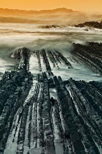
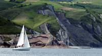
Therefore, removing this layer disappears a record of enormous geological value. However, the K/T limit can be seen in more places, such as Algorri (Zumaia) is well known. On the contrary, UPV/EHU geologist Arantza Aranburu warns that we do not know or what we are losing in many other places, and stresses that “they are often irreversible losses”.
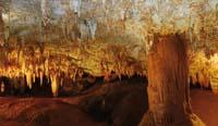
Aranburu works especially in the caves and, according to him, few know what is and the importance of the cavities of the Earth compared to the rocks found on the earth's surface.
"What do we know about the caves? asks Aramburu. She responds without waiting for other people's response: "archaeological and paleontological sites; deep and extensive holes, by the hand of speleologists; and beautiful speleotemas (stalactites, stalagmites...), like those of Pozalagua. Everything else is almost unknown."
Aranburu claims the need to know what we have in the subsoil, "and then they will decide what to protect, how and for what." First, however, it is essential to inform the public why it is so important to know the structures that form in the caves, as well as the sediments that occupy them: "Among other things, they keep a record of the climatic changes that occurred abroad, and when someone takes out of a cave a stalactite or a clay, we lose an opportunity to know the past."
The concept of geodiversity emerged in the 1990s to avoid its occurrence and highlight the value of geological heritage. It was born by analogy with biodiversity and was closely related to the need to protect heritage.
According to the definition of the time, geodiversity would be the natural variety of the earth's surface, including geological, geomorphological, soil, hydrology and other systems created by natural processes and human activities.
Broad and inclusive definition
Over time it has become the definition of geodiversity. Some experts reinforced the idea that it is a substratum of biodiversity, whose definitions include, in addition to the aforementioned aspects, a cultural and social perspective.
Thus, in recent times geodiversity appears related to the sustainable development of environments of scientific interest and tourism and educational initiatives. UNESCO has also opted for this, which is clearly seen in the figure of the geopark. In fact, to receive the denomination of geoparke, in addition to the scientific value of the place (geological, archaeological, paleontological) is taken into account its reflection in culture, its educational and informative possibilities, as well as its possibilities of exploitation, from quarries to tourist itineraries.
And it is that having geological value is not enough to receive the denomination. According to Chris Woodley-Stewart, director of the English geopark North Pennines, "geoparks don't just care about rocks, but also about people. For them it is very important that many people feel like visiting them and enjoying the geological areas. Our goal is to maximize geotourism to boost the local economy and help its inhabitants understand the evolution of their environment."
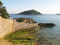
That is, not only does it take into account the geological value and uniqueness and simplicity of the area, but also its educational and tourist value. On this road, Zumaia, Deba and Mutriku have taken important steps in recent years. Thus, for example, the Algorri House of Knowledge of Zumaia and the Nautilus Interpretation Center of Mutriku organize various educational and informative activities, inaugurating in 2008 the replica of the cave of Ekain and jointly offering for the three municipalities geotourist tours.
In the First Conference on Geodiversity of the Basque Country held in May, geodiversity was exposed. It is therefore a broad and inclusive concept. However, the organizers and participants of the conference did not just talk about the aspects of the definition, but also intended to lay the foundations of the Geodiversity Strategy of the Basque Country.
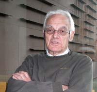
At the conference, geodynamic professor Antonio Cendrero presented an evaluation methodology that helps design strategies and decision-making.
First, Cendreo gave his own definition of geodiversity: "Set of abiotic aspects and resources (rocks, minerals, fossils, structures, soils, landscapes) located above or below the ground that can offer material elements or environmental services of public utility."
Need for a methodology
This definition clearly shows that it takes into account exploitation. In order to assess the heritage elements of geodiversity and achieve sustainable exploitation, it is very convenient that Cendrero has a common methodology at the international level.
However, it still does not exist, according to him there are numerous research works on geological heritage, classifications and studies of impact of the farms, but he does not know a methodology that contemplates all aspects related to geodiversity -identification, inventory or cataloging, evaluation, conservation or protection and valuation-.
The objective of the Cendrero team has therefore been to develop a methodology that contemplates the aforementioned aspects. Thus, to evaluate the heritage elements of geodiversity they combine scientific and intangible criteria. The latter include leisure, culture, interest in education, sponsorship, etc. The evaluation of heritage elements, according to Cendrero, "is between scientific study and artistic, aesthetic and cultural evaluation."

Quantitative assessment is based on criteria of place quality from a scientific point of view, possibilities of use, risk of loss or deterioration and need for protection.
The methodology has been applied in different places in Cantabria and Gipuzkoa and has been contrasted with the opinion of a large group of experts to assess its validity or not. In this way, it is observed that the results are quite similar. In addition, they have contrasted the results obtained with their methodology with the money invested by society in these places, demonstrating that it is also valid.
Therefore, Cendrero has concluded that with the developed methodology "subjectivity is reduced". He also stressed that the process becomes transparent and that the results are repeatable. We are currently working on refining the methodology and have already identified several points to simplify the method.
Given that in the future geodiversity will be extended and reinforced further, it will be beneficial to have such methodologies that help authorities in decision-making and allow people to have a tool to evaluate these actions.
Zu idazle
Zientzia aldizkaria

