

How do you create GPS maps?
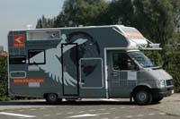
Behind GPS maps there are hundreds of people who travel thousands of kilometers a year. The multinational companies, Tele Atlas and Navteq, working in the production and marketing of maps, have vehicles adapted to analyze the environment. They are called Mobile Mapping Van or mobile mapping vehicles.
Each of these vehicles has six digital cameras capable of taking three photos per second. Two of these cameras are aligned to offer stereoscopic images, that is, they allow to obtain three-dimensional images and calculate distances in different directions. Along with positioning sensors, the cameras collect real data while the vehicle advances with the usual speed on the road network.
The vehicle includes the processing unit that allows you to view the information collected, convert the objects into digital images and compare the information identified with the cartographic database.
Permanent update
The first studies began more than 15 years ago, but the first prototypes of mobile mapping vehicles, very similar to the current ones, were suspended due to technical problems. In fact, in the late 1980s technology was not prepared to accumulate so much data. The volume of information was so large that it was impossible to keep all these gigas. This technology has evolved a lot over time and currently information collection devices are much more efficient.
Tele Atlas, for example, has 22 uninterrupted data collection vehicles across Europe mapping 100,000 kilometers of roads a month. Because work never ends. Constant updating of information is necessary, since every year 15% of the data change: new names are created, new avenues are opened, street addresses are changed... Therefore, to ensure the regular verification of the main road network and the review of secondary roads, all vehicles follow a careful program.
According to Tele Atlas chief operating officer José María Zolle, the biggest problem is having the map updated and not creating the map, just as many people can think. Creating is, in short, an expensive but rather simple process. However, keeping it updated is very complex, because you have to know what has changed at all times and act quickly.

Once all the data is collected, it is sent to India, the Tele Atlas building, where the data collected is processed. The verification, adaptation, location and quality control of the data is then carried out in the central office of Madrid, as well as in other territorial offices such as the office of Vitoria-Gasteiz.
All information collected by mobile mapping vehicles is stored on disks and archived for subsequent uses. These discs form an image file always available, which is a great advantage, so that you can check the discs whenever you want without having to send vehicles to a specific area.
The GPS device market will continue to grow in the future. While mobile mapping vehicles take kilometres by road, GPS maps will have more and more information, quality and new safety services for the steering wheel.

Zu idazle
Zientzia aldizkaria

