

The journey that extended the world
21 December 1521, in Tirades (Molucas). The sailors of both boats greeted in tears. One of the boats needed repairs and couldn't go out to sea. And the other one, when you saw. Elcano decided to reject the initial idea of the expedition and take the reverse path. The wind was opposed, even Portuguese, and it would break the king's order. But if they managed to get to Seville, it would be worth it; the king would also forgive him, for sure, because in addition to carrying the boat stuck, they were going to turn around the world.
When they left Seville in 1519, they were not even going to pass their heads. The objectives were to find a gateway to the sea seen six years earlier by Núñez de Balboa in the American west and, navigating that unknown sea, to reach the Moluccas. There were some of the most precious treasures of the time: spices.
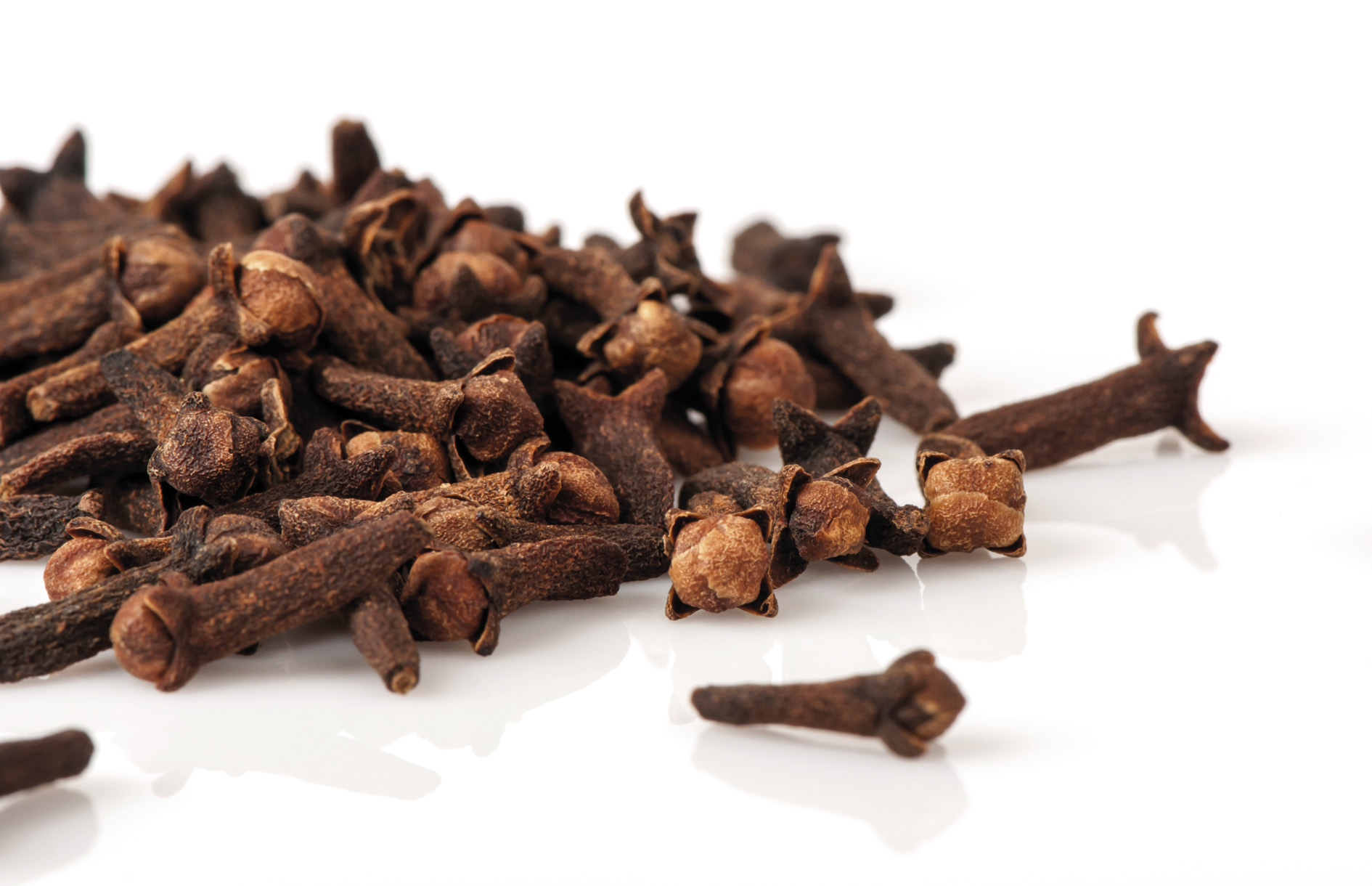
“They were used to preserve the food and cover the taste of those who were not in a better state; there were no refrigerators,” says medical doctor and historian Daniel Zulaika Aristi. The nail was the most expensive and the least space it needed to transport. “It was said that it improved sight, served to fight fever and cold, stimulated the bladder and cleaned the colon and, with milk, improved sexual relations. It was a wonderful and miraculous theme, very expensive, a gift among the noble.”
The Portuguese dominated species trade. Around Africa, at a cost, they reached the territories of the species. Magallanes also wanted to participate in the business of species and, angry with the king of Portugal, developed a plan to conquer Spanish with the help of the cosmographer Rui Faleiro. In a westerly direction, he proposed that he could get to the Moluccas. Thus, Spain could obtain appreciated species. Moreover, according to Magellan estimates, the Moluccas could prove that they belonged to Spain.
With the Treaty of Tordesilla, Portugal and Spain had the world divided. In the west of Cape Verde, 370 lees, a vertical line was established; the new lands in the east of that line belonged to Portugal and those in the west to Spain. But how far it wasn't defined.
“Magellan calculated the position of the anti-meridian of Tordesilla and Molucas showed the king that the Moluccas were within the Spanish demarcation,” explains Nagore Davila Cabanillas, a professor at the UPV and an expert in cartography.
“They knew that the world was a sphere, they had Ptolemy’s theory very internalized: As God only created perfect forms, the world should be round,” says Davila. But they thought he was younger. Eratosthenes Although in the year 230 he gave an almost direct measure, Ptolemy, II. In the 20th century, the world was smaller. “In 1300 the work of Ptolemy was rediscovered and the following cartographers were based on it.”
Key maps
Maps were very important resources. “They became a political and strategic instrument. On the one hand, they were very difficult tasks and, on the other, they were the key to conquer new territories before the others.” They were within the reach of a few and were often secret, although not all acted the same: “In Portugal the official maps were very secret and there was a death penalty for those who spread them. In Spain, copies were made to give foreign visitors their discoveries.”
Davila highlights the map made by Juan de la Cosa in 1500. The American continent appears for the first time. And it also picks up the discoveries of the Portuguese towards India. “The vertical line probably marks the meridian of Tordesilla, although there are different theories.” The Cantino planetarium of 1502 should also be highlighted. “For the first time, latitudes calculated with stars appear. You can say that's where modern cartography begins."
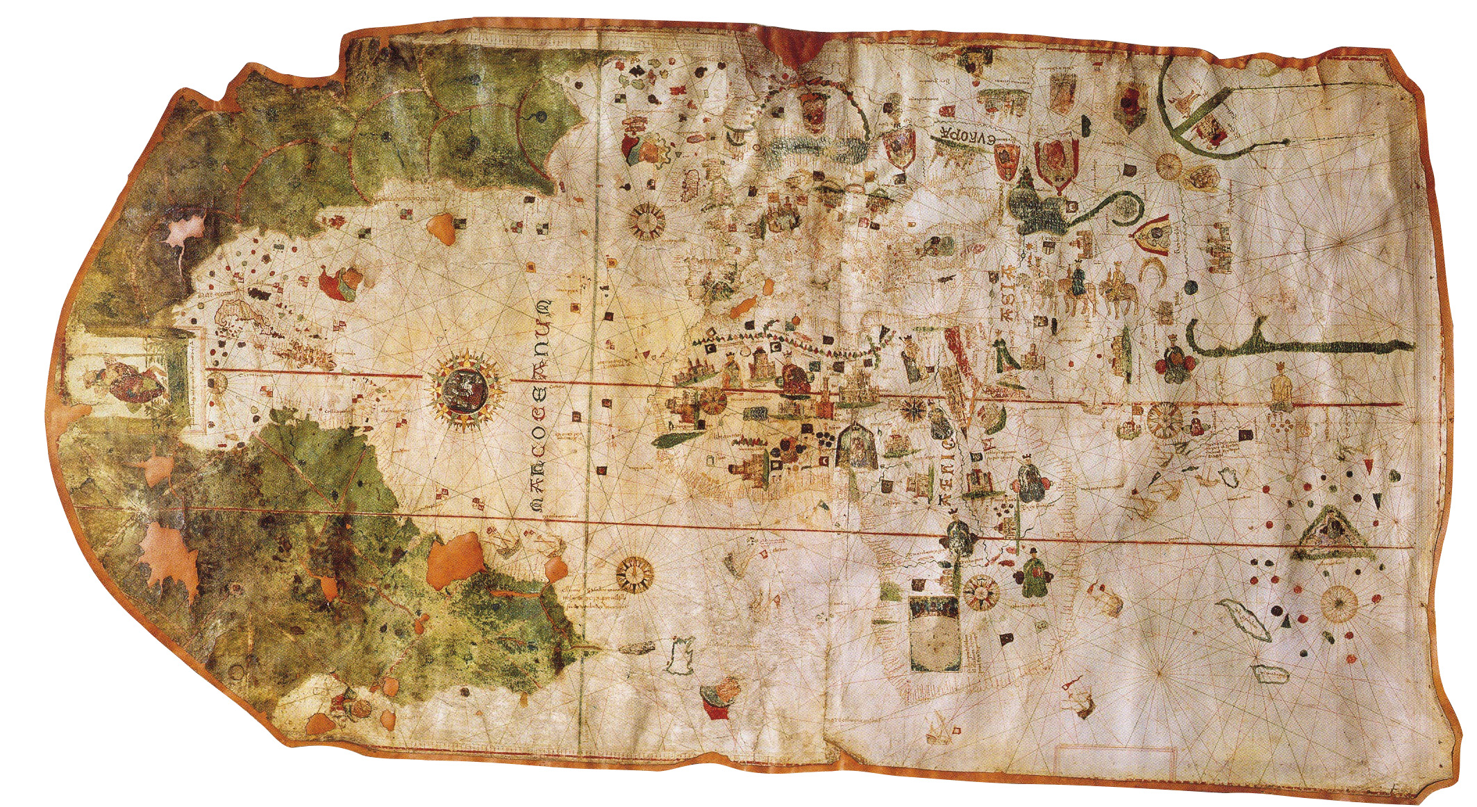
Waldseemüller's planetarium was the one that named America. Differences began to appear in the projection: the meridians are curved lines and the parallels are concentric lines. “Only the American Atlantic coast is defined and the Pacific part is collected as Terra Ultra Incognita. It is curious that America and Asia are divided, as Núñez de Balboa still did not find the Pacific.”
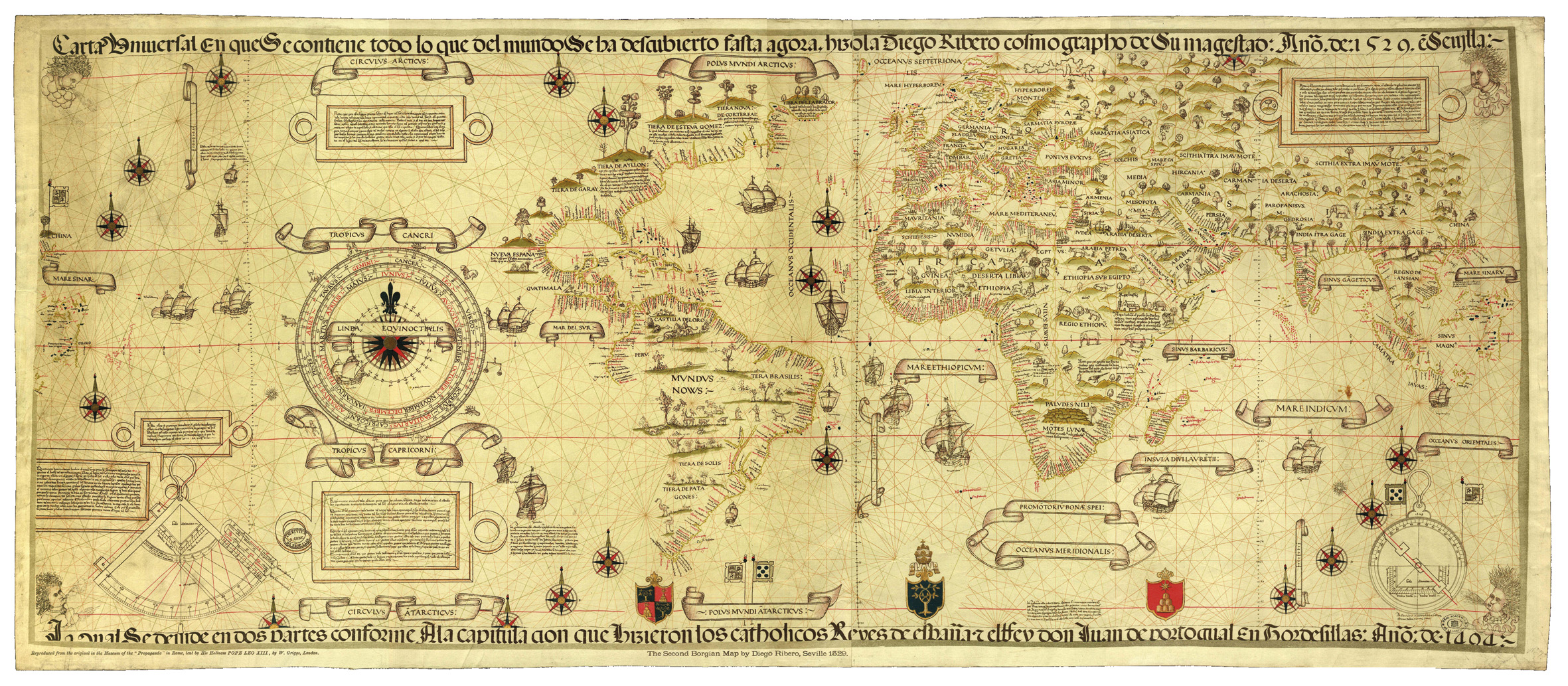
King Fernando II, in 1508, established guidelines for the elaboration of new maps in which all ships returning from the expeditions should report on all findings and with this information the maps would be updated. It would only map the known, regardless of fantasy, subjectivity and myths. And he created the appointment of a “lead pilot” to take charge of it. “Cartography for the expedition prepared by major pilot Diego Ribeiro. The documents contain 23 letters or maps.”
Fishing boats
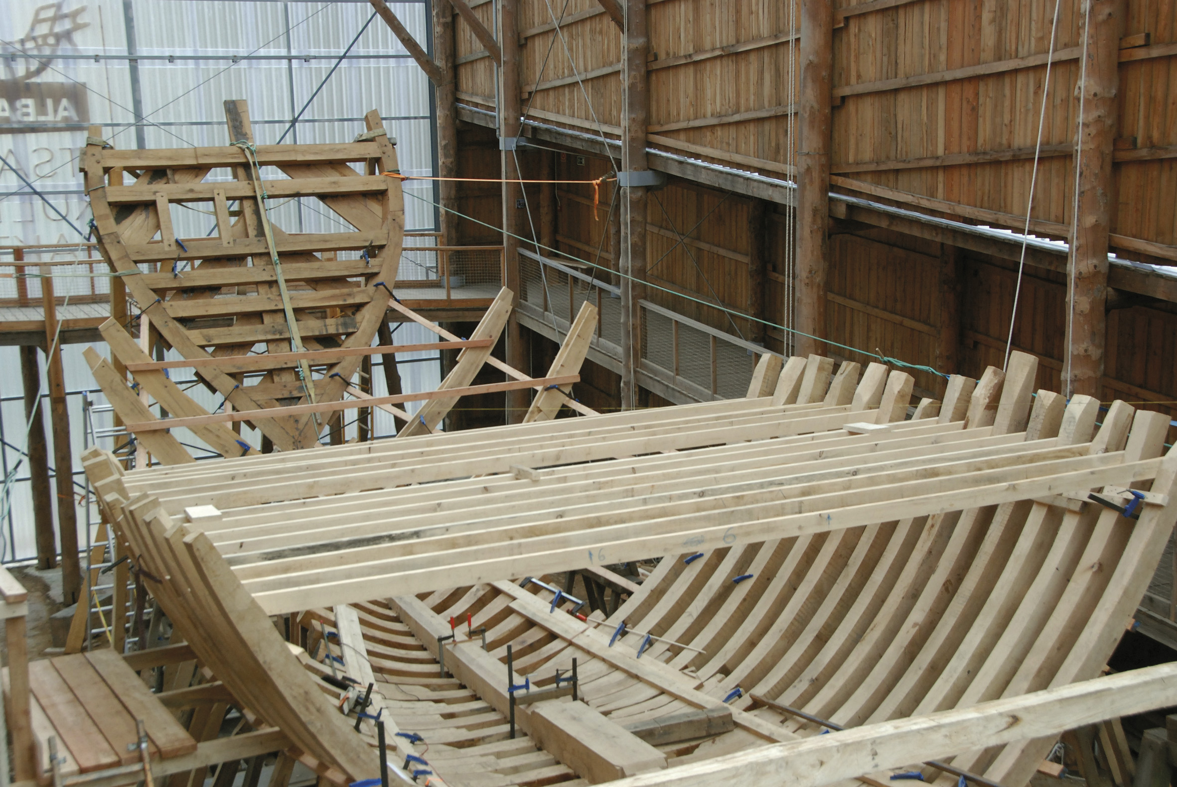
Five boats from Seville came with them. “They were the most modern and advanced of the time,” explains Xabier Alberdi Lonbide, scientific director of the Basque Maritime Museum. In fact, this model of ship had just been created a few decades earlier. “The change was very important, it revolutionized the shipbuilding system itself.”
XV. Until the 60-70's of the 20th century, transport vessels built the hull cover first and then the structure. Once this was discarded, they would start using a completely opposite system: first structure and then skin.

In this way, more resistant containers were obtained and the wood was used much better. “One of the causes of this change may be the change in forest exploitation. By the end of the Middle Ages, there were hundreds of ferreries and hundreds of boats. They started to have a lack of wood. Then came the first legislative measures to protect and regenerate the forest.”
This change began on the Iberian peninsula, especially on the Basque coast. “XVI. In the 18th century there is no other power that can compete with the Basque shipbuilding industry. And that was high level XVIII. At least until the end of the century,” explains Alberdi. “The Basques made this profession cheaper and more effective than anyone. And behind that efficiency is technology."
“The Basque transport fleet became the main fleet in Western Europe. They would be at the service of the Italians, English and Andalusians. And XVI. and XVII. Eighty percent of the ships that traveled from Seville to America for centuries were built on the Basque coast.”
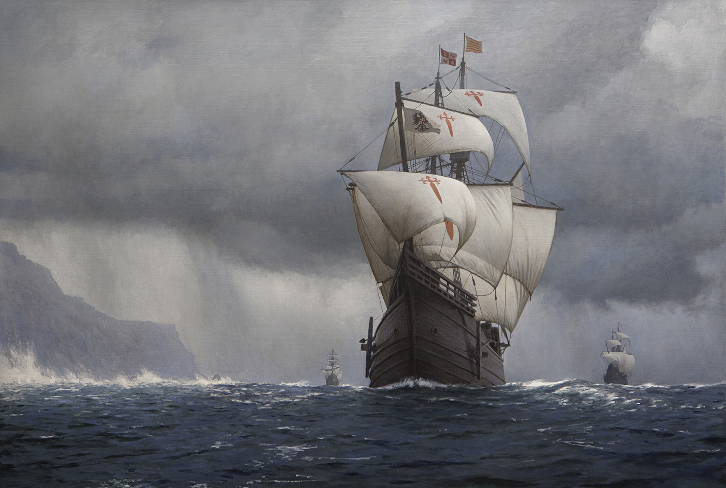
“The king of Castile acquired in the Basque fleet the ships necessary for war and expeditions.” And they also did so for the Magallaes-Elkano expedition, which chose the most advanced ships and appropriated them. Three of the five vessels of the expedition, Victoria, Trinidad and San Antonio, were Basque. “They were not designed for ocean navigation, but for trans-European transport. But they showed that they are really effective for ocean navigation.”
They weren't big containers. “Precisely that expedition was one of the factors that drove the start of the construction of larger ships, since one of the main problems they had was the small size of the ships,” explains Alberdi. “They thought these boats would be enough to get from America to the Far East. But the supply these boats could bring was scarce to make that path.”
The challenge of surviving
They didn't know that when they left Seville. But they were very clear that they needed healthy kids. Therefore, at the time of his departure, Pedro de Basozabal did not allow him to embark due to illness. “It was essential that they should not be put into packaging from the start,” explains Zulaika.
In fact, in the conditions in which they traveled, survival was a real challenge. “Imagine 60 people living on a 90-m2 floor, working, sleeping, eating and doing their needs.” And no water, no hygiene. Rats, cockroaches, lice, bedbugs...On the equator, in full sun; with tropical storms, all day wet; or almost naked in Antarctica, frozen. “Don’t think in adverse weather conditions they could access the basement. The basements were locked, they lived on the boat.”
There was a medical surgeon and three barbers. “They were not doctors who had studied in faculties,” says Zulaika. They cut hair and beard, they were dentists, they drank blood, cut abscesses, authenticated wounds, amputations, and all without the possibility of eliminating pain. “They did many things and had very bad results. Almost the only thing they did in the face of diseases were blood draws. And if you also bring blood to a patient… Many times they only anticipated death. There were very young people, between the ages of 11 and 16 for the seas and tolls. They were more likely to fight disease.”
The five boats left on September 20, 1519, with some 240 healthy young men and boys. After a stop in the Canary Islands, in 75 days they arrived on the Brazilian coast.
Their navigation technology was very basic: the compass to know the direction; the quadrant and the astrolabe to calculate the latitude; and a sand clock and a rope with the knots, to calculate the approximate length in which they were located. “Today it seems impossible, but they had no more,” Alberdi says. “In the notes received by the pilot Francisco Albo it is noted that the calculations were carried out uninterruptedly, ‘calculation’ (I estimate) insists time and again on determining the number of legumes that have moved or the place where they work.”
In open sea with sky
For these calculations astronomy was essential. “When there were no more references, they used heaven,” explains Virginia García Pena, an astronomer of the Aranzadi Science Society. “The sky was the GPS of the time. Pilots had to know astronomy. They had to know the movements of the sky well.”
They used the sun during the day. “To do so, they needed an astronomical calendar that said the position of the sun every day of the year.” And at night they had the Polar star. “Being on the axis of rotation of the Earth, it is the only star that does not move in the sky. It indicates where the north is and serves to calculate the latitude. Here we see 43 degrees, and if you head north, you'll see it getting taller and taller. You know you are at the equator when you see on the horizon and you have passed to the Southern Hemisphere when it disappears on the horizon.”
They also knew the sky of the southern hemisphere. “It has always been said that Magellan discovered the sky of the southern hemisphere, but on the one hand there were people who lived in that hemisphere and knew it well. On the other hand, the inclination of the axis of rotation of the Earth has been changing, knowing the Southern Cross at the time of classical Greece, a constellation that marks the South. And finally, the Portuguese were passing through the cape of Good Hope, where the southern hemisphere is also known. The Magellan cloud galaxy was not found either by Magellan, which all sailors who moved around Africa saw them.”
Without astronomical discoveries, therefore, they were the ones above that saw the Southern Cross in the sky. Exploring the South American coast and after several scales, in October 1520, without knowing it yet, they begin to step into the desired step: Magellan Strait. Santiago sank before and San Antonio left the expedition in the same strait and returned to Spain. The remaining three ships took 38 days to walk the strait.
Pacific, a never-ending desert
They left the sea on November 28, 1520. Nor did they remain for supply. They didn't know that they had such a wide sea in front of them, the widest sea ever sailed. For three months they would not touch land. Some began to grow dentures, then they began to bleed to death. “One third of the expedition died of scurvy,” says Zulaika. In the Pacific 19 died; from Moluccas to Spain 15; and when Trinidad tried to return from Moluccas to America 31.
“It was a new disease. It appeared when the Portuguese started traveling to India. It appeared two months after leaving the soil, at the end of the vitamin C reserves of the body without eating fresh foods. At three months they died.” If they came to land, they were quickly cured: “Bleeding was stopped in 24 hours and gums began to heal in 48-72 hours.”
On March 6, 1521, the cry “Earth, Earth!” was heard. Guam was the island. From there they went to the Philippines and finally came to Molucas on November 8. Magellan was murdered in the Philippines and burned on the Camino de la Concepción for lack of enough crew for three ships. Victoria and Trinidad arrived. Elcano was then the captain of the Victory.
The return to the world
The boats were filled with species and had to return to Seville. When they left, however, Trinidad began to catch water, carrying too much. So, knowing that the Portuguese were close, they decided to take Victoria as soon as possible. In fact, they had to migrate to America. The king's orders were clear: “Don’t discover or do anything in the demarcation and the borders of the sacred king of Portugal, or in their harm.” But Elcano decided to take the opposite path and therefore turn the world around.
They came to the first Timor, from where they traveled to Cape Verde for almost five months without touching any land. They knew it would be very difficult to get there, but they should avoid getting closer to the Portuguese lands. “The Portuguese sailed there and knew the distance behind Good Hope,” explains Alberdi. “But the Portuguese sailed the coasts and they traversed the Indian Ocean without references. It is surprising how precisely they were able to reach the end of Good Hope.”
They arrived in Seville on September 8, 1522, with the greatest feat in history. “Today it would be like going to Mars,” says García. “Using almost exclusively astronomy and not knowing what the planet was like, turning the world around is incredible. In my opinion, from then on, the concept of planet gained real meaning.”
“All the discoveries made during the expedition were collected on several maps by Diego Ribeiro,” explains Davila. One of them is the one he published in 1527. “It’s the first scientific map. It has perfect latitudes. And with him began the decline of Ptolemy.”
“It was a change in the measures of the planet,” says Alberdi. “The world was wider than they thought. So they knew what was there. But they also sowed the seed of what needs to be done to navigate the oceans.”
In a second expedition they were officially headed to the Moluccas. But, according to Urdaneta, when Elcano died, his goal was Japan. “I wanted to find the way back. Elkano was clear that they did nothing if they returned to Molucas and did not know how to return. I wanted to go to the Japanese coast, because to return from Molucas is what you have to do, take the Kuroshio current and get to Mexico.” Finally, Urdaneta managed to solve it. “That’s incredible, it opened up to Europeans ways to come and go anywhere in the world. And that's narrowing the world."
“When I imagine that these 18 men arrive in Seville, I think that, besides bringing all these tons of nails, they do know, even if they don’t know, an important knowledge,” says Zulaika. “They have seen that there are no marine monsters, that the sea does not end in a waterfall or that in the equator water does not boil. And they've realized that man is one, all over the world, that there are no monolingual beings or with their heads in the chest. They abandoned the myths. The expedition provided rationality and scientific knowledge”.
Two days before arriving in Seville, in San Lucar de Barrameda, Elcano wrote a letter for the king. It was very clear what the greatest achievement was. “But as your majesty will know, the most estimable and disturbing thing is that we have found and rounded all the rotundity of the world, going west and coming from the east.”
Zu idazle
Zientzia aldizkaria

