

Rivers, kidneys of the coast
Rivers and streams have always been subject to difficult or rather rare study for environmentalists, since the operation of these systems (strong flow fluctuations, unidirectional transports of matter, origins of energy sources...) does not conform to the air from traditional ecological points of view (balance of nature, recycling of materials from strict systems...).
Therefore, most of the studies carried out until the middle of this century focused on the zoning and pollution of the rivers, leaving aside a truly integrated approach. The rivers, in addition to the water surplus of the basin, collect a series of dissolved and particulate materials that offer an integrated view of the processes of precipitation, sedimentation, weathering, etc. that occur throughout the basin. The gradients of these systems give different physical and biological conditions throughout their journey, favoring the diversity of living beings. In addition, rivers are not only means of transport, but also very active spaces for the transformation of materials. Therefore, rivers are very unique and interesting ecosystems.
Physical characteristics of rivers
The rivers are born in places where the balance between rainfall, filtration and evaporation is positive, directing this surplus of water through the line of maximum slope. In addition to water, they transport crushed and dissolved materials that erosion gives off in the basin, which implies a dynamic balance between erosion and sedimentation processes. As for particulate materials, they can be transported in two ways: as a suspension load or as a bottom load. The particles in suspension are usually small and low density, and due to the turbulence of the water appear quite well separated in the entire column of water. The bottom load, on the other hand, consists of larger particles that are transported in dinbuluca.
Over time, and depending on the energy provided by the volume of water and the slope of the substrate, the river can adopt its equilibrium profile, which would be in dynamic equilibrium with the current topography and degree of erosion. In this balance profile, the springs have a strong slope, this being the erosive part of the river, and the materials of detail detached from it (clays, sands or stones) are transported, breaking and rounding along the river, accumulating in the depositional part of the river. First the coarse grain stones accumulate, then the sand, which only accumulate in the final part of the river (by decreasing the speed of the current). Sometimes there may be a phenomenon that breaks the equilibrium profile (ground jump, earthquake, sea level alteration...), but in these cases another equilibrium profile is quickly recovered.
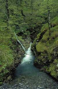
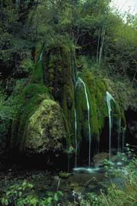
In the regions of young relief the vertical gradients are usually hard and in them you can better appreciate the zoning of the rivers. Near the spring is an area of waterfalls and ponds, dominated by large stones on the substrate. The river runs in narrow valley and the channel is quite linear, especially submerged. As small races are collected, the volume of water is increasing, and as the slope is reduced below a critical level, we move on to another type of regattas or rivers, especially in climates where annual flows are drastically intense: the downstream.
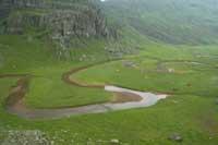
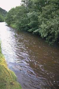
Here, with the reduction of water energy, the river can no longer transport so many stones, which accumulate at the bottom, often hindering the passage of water. Thus, a large rocky alluvial plain is formed, in which the river occupies only a small area of this plain, often altering its route depending on sedimentary deposits. As the river moves away from the mountain, the slope and speed decrease, so the particles it can carry will be smaller and smaller. From a moment on, the bottom is usually sandy or clayey, with an extensive irrigated plain (area that is only immersed in flooding), and the channel will follow numerous meanders.
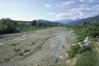
On the outside of these meanders there is an erosion, and since inside the speed is lower, the sediments accumulate, so the meanders tend to migrate. These meanders are often broken and horseshoe lakes remain that only have contact with the main river in the floods. When the river reaches a lake or the sea, the water speed is very slow and if it carries enough materials, the sedimentation rate will be high, forming delta.
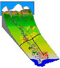
In most languages is the separation between the river and the river, and in all of them are distinguished, approximately, erosive zones (with rocky bottom and strong slope) and depositional zones (with sandy or clayey bottom). Greek rhithron and potamon have been used in limology to represent the river and river respectively. The easiest way to fix a stretch is to sort it. It is said that the stream formed by the spring is of first order, by joining two streams of the same order repel it to the highest order, being the limit between the stream and the river in 4-5 orders.
Rivers evolve parallel to the landscape: as a region erodes, vertical gradients decrease, resulting in fewer erosive zones and more depositional zones. In this way, the river is changing from a young profile of balance to a profile of maturity, until finally a penilautada is formed at sea level.
Basin and river
The river reflects the conditions of its basin, since its physical-chemical characteristics depend on the processes that occur in the basin. On the one hand, the lithological composition of the basin is very influential. In limestone regions the water is filtered and the important part of the drainage is underground, which gives the river a special dynamic. Sometimes, all the water in an extensive karst zone is directed to the main springs, which throughout the year maintain sufficient temperatures, chemical composition and constant flow conditions. However, rivers of insoluble substrates such as granite are usually very oligotrophic, limiting plant production. In evaporite stone basins like plaster, halite, etc. the water is very mineralized, preventing the appearance of certain stenohaline animals. Also, if there is a strong erosion in the basin, the river sediments tend to be filled with clay, making it difficult for algae to appear.
The scattered vegetation in the basin can also be of great importance. On the one hand, the existence of a more developed or simpler vegetation, at its erosion level, and consequently, the amount of materials that will reach the river. In addition, this vegetation is largely the one that controls the physical-chemical characteristics of the river water. If the river is under the jungle, the temperature remains lower and constant, increasing the solubility of oxygen. But it is not the only influence of the forest.
The first study to explain the concrete relationship between vegetation and river water in the world was conducted on the Hubbard Brooks River in the US. It quantified all inputs and outputs of matter and energy from a whole basin. It was observed that the local forest has a great capacity to recycle food, since the water is very oligotrophic. After the construction of the matarrasa large amount of soil was lost, significantly increasing the concentration of water in nutrients, and the volume of water, especially in summer, due to the reduction of evapotranspiration. In addition, the soil was greatly impoverished, both by increasing cleanliness and by the loss of nitrogen to the atmosphere due to decomposition and denitrification.
Following this pioneering research work, the relationships between vegetation and the river have been clarified. The composition of the forest influences, for example, that conifers recycle less cations than the leafy ones, which causes a greater arrival to the river, and in areas where the vegetation is leafy, the main energy source of the river community can be the litter, but its seasonality imposes special conditions to its inhabitants. In some cases, especially in flat regions of cold climates, the river is usually surrounded by fields of cultivation, and the acids generated in the decomposition of coal make the river very poor, often with abundant dissolved organic matter that gives the water coffee color. Besides in the vicinity of Zoikaztegieta, in many areas of sandy soil there are these "turbid waters", since the sand is not able to retain the acids released in the decomposition of the litter, reaching the waters of the rivers.
In addition to the vegetation, as could not be otherwise, human action can have a strong reflection in the rivers, both by increasing the sediments they carry as a result of erosion, as by agricultural activities, livestock, etc., which lead to it a large amount of nutrients and organic matter.
The Ebro delta, so famous on the peninsula, is largely of human origin: In the Middle Ages grazing was the main economic activity of the kingdoms of Navarre, Aragon and Castile, and deforestation caused by its empowerment resulted in the strong wear and tear that is observed today in many places. The enormous amounts of sediments were channeled along the river and in a few centuries the Ebro delta advanced thirty kilometers. At present, however, this river is fully regulated and most of the sediments it carried remain in the reservoirs, when the sea is eroding delta.
In fact, each of the streams that are collected can be very different and have a great influence on the main branch. As we descend through the river, however, water reflects the average value of the larger surface characteristics and it is more difficult for an estuary to alter both its chemical or physical characteristics. That is why as we descend, the chemical inertia of the river increases.
Variability of rivers
As mentioned above, rivers are born in places where the balance between rainfall, evaporation and infiltration is positive. However, precipitation is usually very irregular, as in some thrombas you can give most of the precipitation of a long streak. Therefore, the flow of rivers also suffers significant declines in time. As for the flow, two types can be distinguished: on the one hand, the basal flow, which occurs when it takes a relatively long time without precipitation (and of course without snow), the flow produced by eviction of the slower aquifers, and on the other, the flow of storms, which occurs in case of precipitation, directly to the river or due to the water circulating to runoff or surface infiltrations.
Depending on the aquifers that feed the river and its river zone, the response to the storm can be very different. The springs, formed mainly by waterproof substrates and vegetation with low water retention capacity, respond very quickly to the rains, that is, as soon as the rain begins the flow of the regattas increases and, very soon, return to the basal flow. If the river is fed by a large aquifer, its response will be slower and more if we talk about the lower areas of the river. Therefore, variability over time can vary greatly depending on the climate, substratum and size of the river, which, logically, will reflect the inhabitants of the area; the more violent and unpredictable the changes, the poorer the communities.
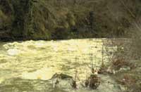
In addition to the volume of water, important physical-chemical characteristics are also modified with the rains. Normally the water is acidified (rainwater has a pH of less than 5.6), diluted (the water, moving faster, has not had enough time to dissolve the mother rock) and is disturbed due to the fine particles it carries.
The most remarkable feature of these flow variations is their importance in the modeling of the channel. It is then that the transport of heavy materials, the transformation of the meanders and the sedimentation in the floodplains occurs. The importance of flooding is associated with its frequency, so its return time is usually calculated. The return time tells us how long we could expect a timely flood.
For example, an average of two avenues of half a year return time will occur. The importance of these disturbances will not be very high, since the river biota will be somehow adapted to this frequent phenomenon. However, the flood with a return time of one hundred years will not be known by most living beings. Over several years, communities living in an area apparently far from the risk of flooding will be transported. Millennial floods of return time are able to move large blocks of rock, produce very high erosion and completely distort the channel.
Therefore, the morphometric and geological characteristics of the basin, vegetation, human action, climate and events of the immediate past will configure the biological community that we will find in the river. This is recovering over time from disturbances such as flooding. However, river conditions are never very constant and, before reaching a state of balance, the new disturbances will transform the community over and over again.
Zu idazle
Zientzia aldizkaria

