

Algorri, the past turned into rock
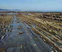
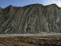
From the geomorphological point of view, the existence of an intermareal rasa is proper. On the Cantabrian coast, and also in Europe, the large esplanade is located in very few places: it has between four and five kilometers inland to the sea. In the background the cliffs rise.
The intertidal rasa is the result of the erosion caused by the waves against the cliffs. Soft, hard materials alternate in the vertical layers of the cliffs, which are easily eroded by the waves, and the harshest protect the soft under the tide level. This protection is not total and it seems that the sea has hit the stretch on the esplanade.
The dynamics of the cliffs of Zumaia is very active, that is, the waves erode quickly the cliff. Hilario would like to measure the retracement speed of the cliffs, which now have no data, but believes that the cliff can go back more than one centimeter per year.
There are indications that the setback is very fast. For example, between Deba and Zumaia, in four zones, the streams that reach the coast must jump to reach the sea. Normally the valleys of the streams are located on the coast in miles of sea, otherwise it can be seen that the cliff goes back to a speed higher than the one that the stream overflows the valley. And that's what happens in Algorri.
In this great intertidal rasa live numerous species such as crabs, macaws, mussels, anemones, algae, etc. These are unique animals and plants that must be able to face very difficult conditions. In fact, at high tide, at little depth but under the sea, and once the tide is down, they stay in the pools. The temperature and salinity of the water are, therefore, variable and, in addition, a competition is generated between those who remain together in the well and each species must develop its protection strategy to advance. For all this, the living creatures of the intertidal rays are interesting, and those of Algorri are no exception.
Page to page
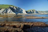
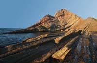
In any case, the cliffs of Zumaia are especially interesting from the point of view of the geological record. In a stretch of eight kilometers the cliffs have no cuts. From the oldest, that is, from Deba to the most recent ones, towards Getaria, it is collected the whole history of more than 100 million years ago until 50 million years ago, through pages. In Hilario's words, "in these cases it is customary that some chapter has disappeared, but here there is no missing page".
It is a very thick book and, as with thick books, "not all chapters have the same interest, some are more significant than others." And in those eight kilometers are collected two great moments of the history of the Earth, both in Zumaia. Otherwise, as a whole, the book deserves the attention of geologists, who provide a lot of useful information: climatic variations, the creation of the Pyrenees, the life that existed in each epoch...
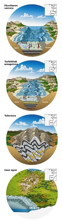
In those times the climate was warmer than today, and a large coral reef was formed at the end of the platform. His witnesses are the limestone mountains that cross the Basque Country from east to west: Gorbeia, Anboto, Aizkorri...
From the reef to the sea, eroded materials were accumulated in horizontal layers. That is flysch. Later, as the Iberian tectonic and eurasian plate approached, the East to West Pyrenees were formed, and thanks to these forces, the previously horizontal layers became vertical. This is how they are seen today on the cliffs of Zumaia.
Significant rotation of rotation
In these layers, previously horizontal and now vertical, the alternation of two types of materials is evident. Some layers are hard and the intermediates softer than they, so they are more worn out. Hardness, of course, is related to the composition of sediments at the time of their formation.
In the sediments were the shells of marine animals (planktonic and benthic foraminifers, and lime nanophosicles) and the clays grounded. From there are all the layers, which are hard or soft depending on their proportion: when the shells of the animals predominate, a hard layer of limestone is formed, while when the majority is clay a soft layer is formed, a marl.
It is easy to relate one and the other to the influence of climate. Thus, when the climate was dry and warm, limestone layers were formed and, when it rained a lot, the tupa. Therefore, the climate cycle can be analyzed by layers. It seems that the rotation of the rocks of Zumaia coincides with the theory of Milankovitch.
Astrophysicist Milankovitch proposed a theory to explain the climatic cycles of the Earth and within it the glaciations. In his opinion, the tilt of the Earth's axis and the eccentricity of the orbit are key to understanding how warm and cold periods alternate, and why glaciations occur cyclically. Well, the layers of Algorri alternate as announced by Milankovitch's theory.
Besides limestone and marl, in Algorri there is another type of rock: turbidite. Turbidite is a layer of sand, sandstone. In fact, the sands accumulated on the platform would occasionally be randomly poured into the sea. In a process of slow natural accumulation, turbidites are interspersed spontaneously.
Asier Hilario warns that turbidites are not distributed regularly. "They begin to appear about 60 million years ago and, with the passage of time (towards Getaria, therefore), are becoming more frequent and older. This is related to the creation of the Pyrenees".
"The Pyrenees began to rise in the area of Catalonia. Like all new mountain ranges, the Pyrenees suffered a strong initial erosion and eroded sediments accumulated in the surrounding basins, as platforms close to Ordesa. On the other hand, the continuous thrust of the Iberian plate generated an increasingly unstable situation in these platforms, causing earthquakes and increasing slope slope. As a result, sand discharges increased, both in magnitude and frequency. Thus, the paleocorronts measured in the turbidits of Algorri come in most of the eastern cases".
Finally, there are places much more margoose than usual. They appear intermittently and although alternating between limestone and marl is maintained, the proportion of marbles is much higher than normal. Apparently, the margoose zones are related to the sinking of the sea. From time to time the sea level decreased and the streams, to reach the sea level, strongly eroded the bed, so many more sediments arrived than before.
Fossils and other fossils
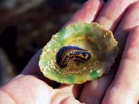
The fossils allow to obtain another type of information. The rocks of Algorri house macrofossils, ammonites and innocent, as well as microfossils, foraminifers. They are the ones that form the rocks and, in passing, provide the most interesting information. Because they are very sensitive to the water temperature, they give relevant information of the place where they are located.
However, among the fossils, Hilario believes that fossilized remains are the most valuable of Algorri. It seems that in the world there are very few places where fossils abound from the footprints of living beings from the seabed. That is why they are important. In addition, these clues allow to deduce how living beings originated them, how they lived, what behavior they had...
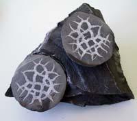
On the other hand, in the area of Deba there are apparently fossil structures, but not fossils but minerals. They are like a ball and are called septarea. They formed in the lower Cretaceous (the oldest cliffs) and are submerged in a detritic rock, in a very dark marge. The septars are of size equal to or greater than an egg and are easily released from the marga. If it opens, inside there appears a nice blank drawing.
It seems that the clays of the seabed were formed when compacting in ball form. Hilario acknowledges that they do not know why they were compacted, but they know how the drawing arose: "When compacting, by pressure, the balls were cracked inside. Over time the slits were filled with calcium carbonate, so the drawings are made of calcite."
Limit K/T
The characteristics mentioned so far can be seen in other places on the Basque or Cantabrian coast. What makes Algorri so special then? Hilario is clear: Besides seeing all this general information perfectly, in Algorrin we see more clearly than anywhere the border between the Cretaceous and the Tertiary (limit K/T) and the Paleocene and the Eocene (P/E). Both are perfectly visible, the assistance is very simple and the distance between them is small. "For geologists, a great chollo".
The K/T limit is 65 million years. In Zumaia is located at the base of the tip of Aitzgorri. It is a very nice place and whose geological value makes it even more attractive. It is related to the loss of dinosaurs.
In fact, the K/T limit is a dark layer of clay. In the clay is the iridium, at a much higher than normal concentration and some microspherulas. The microspheres have structures called spinels rich in nickel and, in certain places, carbonera. As for the fossils, it is worth mentioning the disappearance of ammonites from the registry, as well as most of the planktonic foraminifers and lime nanophones. In particular, foraminifers decrease by 99% and diversity by 54%, while the number of nanometres decreases by 85% and diversity by 25%. This extinction coincides with that of the dinosaur.
According to Hilario, "there have been massive extinctions much harder than it on Earth, as in the Permian, but somehow, the most famous, because the dinosaurs were fascinating and, probably, it is also the most recent." In any case, the K/T limitation is special for paleontologists and, according to the most accepted theory, the collision of an asteroid and the consequences of the collision marked the distinction between Cretaceous and Tertiary.
There is much evidence in favor of theory. The crater created by this asteroid is located in Yucatan and the footprints are perceived throughout the world. In Zumaia they are in sight. For example, it released the iridium to the atmosphere and the layer that was formed once precipitated looks very clear in Aitzgorri. Microspherulas are small, impact released droplets that cool in the atmosphere and get trapped in the layer by falling into water. The splashes that fell to the ground instead of falling to the water caused fires, and from it the soot is derived.
Limit P/E
In addition to Zumaia, in Sopelana and Hendaia the K/T limit in the Basque Country is also observed, but in Zumaia there are previous and subsequent layers without interruption, besides the P/E border between the Paleocene and the Eocene. Hilario considers that this limit is even more important than the limit K/T.
The limit P/E, located at the entrance of the beach of Itzurun, is between 54 and 55 million years old and is part of a red clay of 1-1,5 meters wide. Special for its geochemical, isotope and paleontological differences with respect to the previous layers. Specifically, its content in calcium carbonate is practically null, the isotopes C13 and C18 decrease notably and, among other things, the benthic microforaminifers that exceeded the limits K/T disappear.
These changes coincided with an accelerated climate change, supposedly associated with the dumping of methane from marine bottom. However, there was a period of heat which resulted in the division between Paleocene and Eocene.
There are also some limitations within Paleocene. They are of category inferior to the limits K/T and P/E, since they are times within the Paleocene (Danish, Selandese and Thanetiense), but well differentiated in Zumaia. For this reason, Asier Hilario and members of the stratigraphy of the UPV/EHU work to make the official borders of the Paleocene of Zumaia.
It is clear that the coast between Deba and Zumaia is a treasure, not only for geologists and biologists, but for anyone. The Basque Government will designate next year as a Protected Biotope to avoid damage to the Treasury. In addition, it will try to declare as geological heritage those sections of greater geological interest.
Zu idazle
Zientzia aldizkaria

