

Analyzing the landscapes of the Euskadi seabed
The seas and oceans of the world have a great biodiversity and a great variety of unique habitats that supply the human being with services and goods such as food, minerals, energy or leisure. Unfortunately, however, some of the actions taken by man to take advantage of these resources can lead to degradation, destruction, fragmentation and, in some cases, loss of marine habitats. Thus, it is considered that there are no oceanic zones that are not affected by the human being, and even more, in 41% of the surface of the oceans, human influence is considered very high. For this reason, marine natural habitats are threatened and it has been shown that they should be managed better than until now.
Unfortunately, knowledge about the size, geographical extent, and ecological functioning of the habitats of the seabed is still very small. For example, even though the world's seas and oceans cover 71% of the world's surface, the quality of information available for the Earth's surface is the same as for 5% and 10% of the marine bottom habitats. These reasons highlight the difficulty of an efficient management of natural resources while protecting habitats and biodiversity.
In order to help overcome these barriers, a research program was designed to map the seabed and habitats of the Basque Country. The main objective of the research was to obtain scientific knowledge on the characteristics, processes and habitats of the marine bottom. At the same time, generate useful information to facilitate the proposal of the most appropriate management measures and the application of autonomous, national and European legislations.
New technologies at the service of the sciences of the sea
Conventional marine sampling methods -- diving, dredging for the sampling of sediment samples and seabed organisms, and technologies for the collection of underwater images -- are limited by depth. Therefore, it is difficult to analyze the marine ecosystem and understand its complexity.
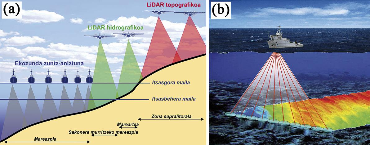
Fortunately, the technological development of recent decades has allowed important advances in acoustic sampling techniques, such as ecoconcentrators and sonars, or LIDAR laser techniques. These techniques allow the realization of maps and the creation of large-scale marine images analogous to soil images (Figure 1a).
Among them, the multibeam echo sounder most used for the creation of the cartography of the Basque coast (Figure 1b). Its operation consists of emitting an acoustic pulse sent from a boat and collecting the echo that generates the acoustic wave when crashing on the seabed. Measuring the time that the acoustic wave has taken to make this trip back and forth, one can analyze the depth of the sea and its physical characteristics.
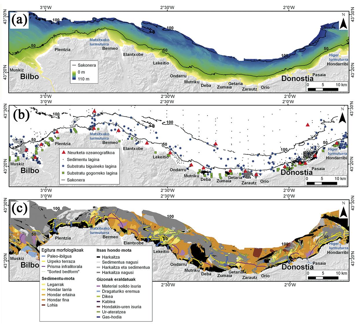
The cartography of the Basque coast up to 100 m (1,096 km 2) took 181 days between 2005 and 2008 (Figure 2a). In addition, for the best characterization of marine background habitats, 2,323 sediment samples and 413 biological samples, submarine videos, hydrographic data and wave energy data were collected (Figure 2b).
All this information was integrated into databases and a geographic information system (GIS) for further analysis and interpretation. In addition, specific statistical models were used to analyze the physical and oceanographic characteristics of the seabed that characterize the habitats of the Basque coast.
Characteristics of the seabed on the Basque coast
When analyzing the data described above, it is observed that the Basque coast is composed of several types and morphologies of marine bottoms. These characteristics are the result of the interaction of the various processes that have taken place in geological history, influenced by tectonic movements, changes in sea level, sedimentary contributions of rivers and climatic conditions, which continue to exist today. Information on these morphological features was used to create the first high-definition morphosedimentary map of the Basque coast (Figure 2c).
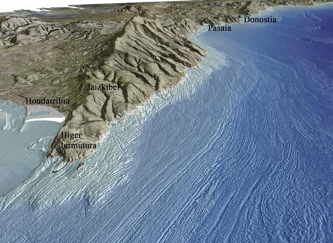
According to the interpretation carried out, mixed seabed formed by rocks and sediments occupy half of its surface, from the coast to 100 m of depth. In shallow areas it is characterized by a rock of roughness and strong slope, while from 40 m of depth the slope of the marine bottom is smaller and the surface of the rocks is softened (Figure 3).
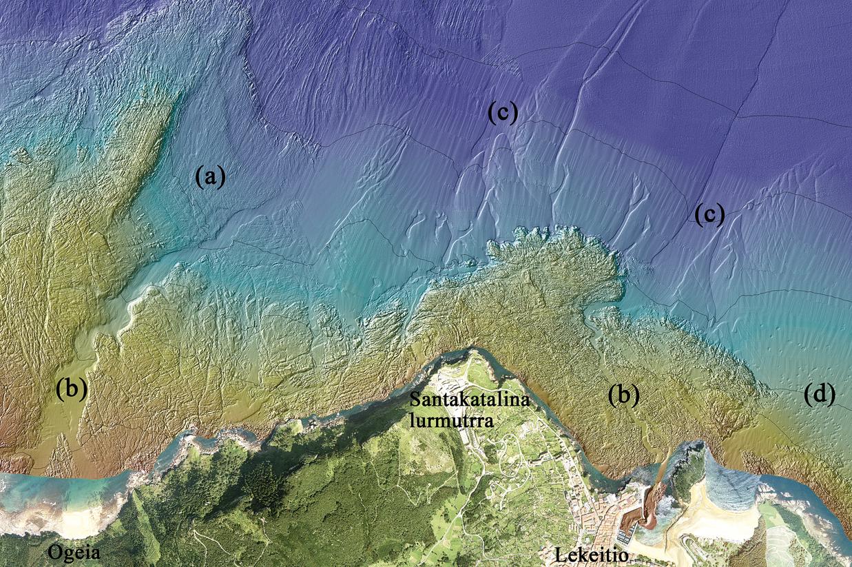
In addition, the characteristic remains of geological processes have been identified in marine bottoms formed by rocks and rocks hitherto unknown. Among them are the channels of the old regattas (more than 40) and the underwater terraces (9). These morphologies are traces of structures created when the sea level was several meters below what we know (Figure 4).
On the other hand, marine sedimentary bottoms appear as residual banks that extend to greater depths from the beaches and the estuary mouths, occupying 36% of its surface. In these seabed, several morphologies have been found that give an idea of the models of sedimentary dynamics generated by the currents.
Finally, the structures created by man have been analyzed. In this sense, the submerged ships and sinks and underwater conductions have been mapped. Among them, the remains of dredgings in ports and navigation channels are those that occupy the largest surface (2%).
The geomorphological diversity and the characteristics of the marine background described above have a great influence on the geographical distribution, distribution of habitats and characteristics of biocenosis, that is, in the vegetable and animal communities that live together.
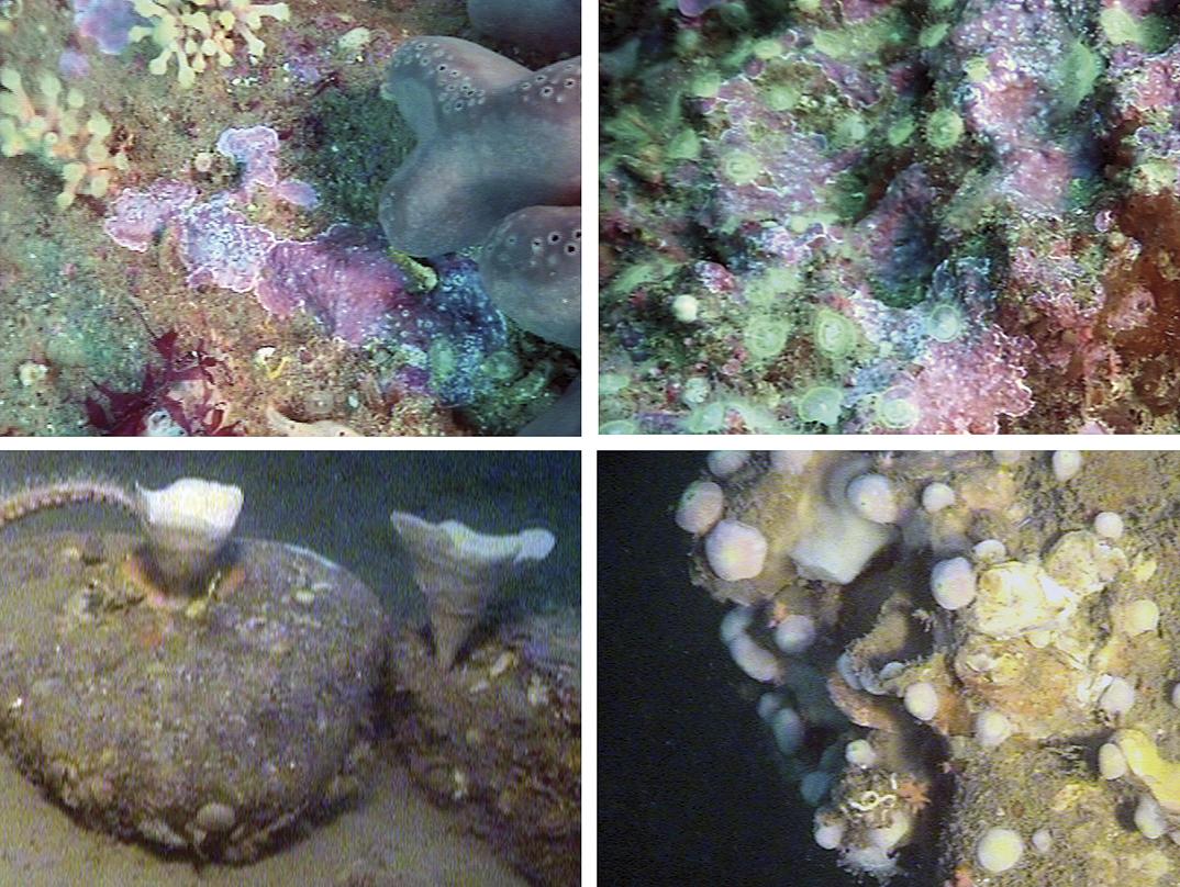
The analyses have revealed that the parameters that most influence biocenosis and its spatial distribution are the depth, the sedimentary characteristics and the energy of the waves in relation to sedimentary habitats. The combination of these environmental factors affects the stability and productivity of habitats, at the same time as they condition the biodiversity, species richness and ecological character of the species. For example, it has been shown that in greater depth, and therefore, in habitats with more stable environmental conditions, species with a longer life, a longer time of maturation and a longer time of growth are found in greater proportion. These characteristics indicate the sensitivity of the habitat and its limited capacity of recovery in case of physical destruction. It is normal to find sponges and corals in these habitats (Figure 5).
Use of marine background mapping for management
The results have led to significant improvements in different areas. For example:
- Know the habitat of some species of commercial importance such as lobster.
- For the management of some species of interest for conservation and conservation, knowing the characteristics and spatial distribution of their most appropriate habitats.
- In the first phase it has also been used to select the most suitable location when installing the energy generation devices of the waves.
- It can also be useful to select marine areas that by their ecological character should be protected.
This research has been an important scientific breakthrough in the mapping of the seabed. On the one hand, the most modern techniques of the last generation have been used and, on the other, the biological, geological and oceanographic data have been analysed together, which has joined numerous fields of marine science.
It is assumed that scientific knowledge is essential to be able to implement the appropriate management measures. The knowledge generated in this research has been published in 15 scientific articles from various international journals and has laid the foundation for other scientific studies. In addition, it has a prominent role in the environmental and resource management of the Basque coast.
Bibliography Bibliography Bibliography
Acknowledgments of thanks
Directors of the thesis, AZTI-Tecnalia and the team that has collaborated in the development of this work.
Department of Environment, Territorial Planning, Agriculture and Fishing of the Basque Government.
MESH Atlantic: Transnational Cooperation Program 2007-2013 of the European Regional Development Fund.
Diputación Foral de Gipuzkoa.
Joxe, Iñigo and Irantzu for the text preparation recommendations.
Zu idazle
Zientzia aldizkaria

- Babesleak
-

-

Elhuyar
Nor gara | Kontaktua |
Publizitatea
| Laguntza
Pribatutasun politika | Cookien politika
ISSN-2603-6614 Elhuyar