

What's under the hurricane?
Elhuyar Fundazioa
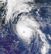
Each year, at the end of summer, the hurricane season begins. The Basque Country, fortunately, is not in the hurricane zone, but it is a terrible time for the population of the United States, Mexico and, above all, the least developed countries of the Caribbean. The massacre caused by Hurricane Mitch last year, for example, will not be forgotten for a long time in Central America.
Hurricanes are natural phenomena that cannot be avoided or prevented. Man cannot divert the hurricane. But it is not difficult to ensure that the consequences, especially death, and to some extent material damage, are not so serious, provided that the population is informed in advance and with the necessary time and security measures are correct. To do this, the first thing to do is to know where the hurricane will form, how it will move and how it will behave, follow up and predict its trajectory and evolution. Many meteorologists and scientists work on it. The most powerful body in the world that studies hurricanes is the National Hurricane Center of the United States. The Center collects and analyzes terrestrial, marine, aerial and satellite data. But the surprise, the surprise of congratulations, does not come from the NHC: this year scientists are using two research satellites to observe the inside of hurricanes in the way that until now was impossible.
Eyes that cross the clouds
In fact, most satellites collecting weather data can only photograph clouds at the top of hurricanes. Now, however, the satellites of the QuickScat and TRMM missions have new microwave sensors that cross the clouds and under them, on the surface of the sea, they can 'see' the state in which they are - precipitation and water conditions and winds. This new data will allow scientists to detect the formation of tropical storms earlier and more accurately predict the course of the hurricane.
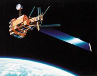
The QuickScat satellite was sent by NASA to orbit the Earth in June 1999. It has a special instrument, the radar diffuser meter, which simultaneously measures the speed and direction of surface winds in seas around the world. So far, other satellites using radar can measure speed, but only the diffuser meter can simultaneously measure speed and direction.
The diffuser meter sends a microwave ray to the sea surface at a given angle. The lightning passes through the clouds without changes and the surface of the water disperses. Some of the microwaves that make up the beam, by rebound, reach the satellite and are collected. The undulating surface of the sea represents high speed winds and reflects more radiation than the smooth surface of the sea.
Using QuikSat data, scientists believe they will be able to detect potential hurricanes one to three days earlier than NHC currently finds. Satellite photos using NHC only show the clouds in the highlands of the hurricanes that are about to be born, but when there are higher clouds above them, they cover the clouds of the hurricane and therefore the underlying hurricane is not visible. Therefore the QuikScat satellite is better.
Clearing and decay at work
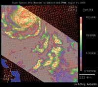
On the other hand, the TRMM (Tropical Rainfall Measuring Mission) mission, which is being carried out jointly between NASA from the United States and the Japanese Space Agency, aims to measure precipitation and geographic distribution of tropical regions. The truth is that precipitation has a lot to do with hurricanes, since in tropical storms precipitation indicates the heat that is releasing to the atmosphere. The higher the sea surface temperature, the greater the evaporation of sea water. When condensed in the clouds, the water vapor releases heat into the atmosphere of the medium and therefore the hot air rises. The increated air creates low pressure through the surroundings, and through the lower pressure to rotate air at the surroundings. This is how hurricanes form.
In addition to precipitation, the microwave sensors of the TRMM satellite can measure the surface temperature of the water under the hurricane and, therefore, knowing this temperature allows to predict if the hurricane occurs, since the formation of it depends, among other things, on the surface temperature of the water.
Traditional weather satellites use infrared sensors to measure the surface temperature of sea water. What is the improvement then? Infrared sensors do not cross the clouds so they can only take the surface temperature of the water in areas without cloud. However, the microwave sensor of the TRMM satellite crosses the clouds smoothly. Therefore, rainfall and sea surface temperature data provided by the TRMM satellite can be incorporated into computer simulation models, which will allow predicting hurricane behavior -force and trajectory.
The original objectives of the QuikScat and TRMM missions were not expected to be used for hurricane detection and monitoring, which has been a surprise for meteorologists. From now on, scientists will have a better tool for hurricane analysis. These advances can provide more appropriate prevention measures in favor of the population!
Zu idazle
Zientzia aldizkaria

