

Doñana Living Water: to understand the disaster
What happened has shaken hard and has shaken for a long time, not only Doñana, but all the sectors that are trapped in the network of the area: economic, political, social and ecological. The red light has been lit in Doñana and has not been the only one of these days. In these cases, comments at the warm moment of the event usually have no value, so the following is the most suitable for a serious reflection on what happened before it cools down. It is necessary to make an obligatory reflection, above all the beasts of the area, to evaluate the words and facts so far, to demand responsibilities and, above all, to start by another way.
All sectors trapped in Doñana's web will have to convince their descendants of what they leave and, therefore, what they drive. Marshes or mines? Urbanizations or dunes? Excessive agriculture or bespoke green tourism? Storks or cattle? Where is the limit?
The current is not the first, since Doñana had already suffered harmful effects. The aim is to analyze the influence that the recent sludge spill in the mine already has in the vicinity of Doñana and its possible future. Always with prudence, because in addition to comparing what has been said these days, it will take longer to know the real influence through obtaining concrete data. To understand the impact, materialized and supposed, it is essential to know the dynamics “own” of the park of Doñana, which has been the one that has predominated in recent years, although not entirely natural.
Geological creation
Doñana is located around the mouth of the river Guadalquivir. The valley from the geological point of view is an extensive depression, full of materials accumulated in the Miocene, Pliocene and Quaternary (last 20 million years). The sedimentation of the Mioceno-Pliocene episodes was conditioned by the movement of tectonic plates Iberia and Africa, sometimes in the marine environment and others in the terrestrial. As for the environment of Doñana, three main formations are observed: margas, limos and sands. The latter, due to their high permeability, give rise to a good aquifer, number 27 in the official catalogue of aquifers.
At the end of the Pliocene, the sea retreated definitively leaving the valley of the Guadalquivir on land. In its new situation the local river network began to form, which eroded the stones at its top, transported the derrubs and deposited them at its bottom, making an important deposit on the stones of the Miocene-Pliocene.
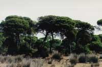
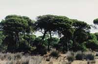
Located at the mouth of the Guadalquivir, Doñana has experienced a significant change in the last 10,000 years. As a result of the last glaciation, the sea dominated the area forming an extensive bay of little depth. The bay gradually isolated itself from the sea by the action of the sand bars, facilitating in its new situation the sedimentation of fine (limos and clays) rich in organic matter, including remains of sand. In these smooth clays the marshes were formed. In some areas of Doñana this collection has a thickness of 150 meters. The internal arrangement (geometry and permeability of the layers) conditions the dynamics of underground waters in Doñana: direction and speed.
Doñana Parks
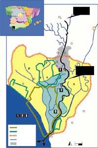
The name of Doñana encompasses several fields: The National Park itself, the strictest of protection measures, with 50,000 hectares; five natural parks, surrounding the front, with 23,000 hectares; and all of them and other adjacent lands, the Doñana Area.
The national-natural classification is administrative. In fact, since 1969, when the legal connection of the Doñana protection zone began, there have been changes in the protection measures to reach the current limits of the park. These limits are largely due to the confrontation between economic and ecological approaches. In this way, the National Park has strict measures, but in the postparks there is an excess of agriculture that is irrigated with the underground waters.
From the point of view of the ecosystem, the National Park is directly related to the adjacent areas, that is, with water. The National Park would not be as it is if it were not the one around it. Therefore, these days there has been a confusion when some say that the flood of fangos has not reached Doñana, since it is only talking about the National Park to avoid that the umbrellas of Inguralde have been affected. Some have also preferred to forget their later influence.
Anthropic activity
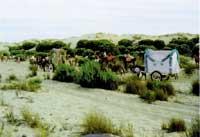
Fishing and hunting were for years the main tasks of the inhabitants of the area of Doñana. Subsequently, livestock and agriculture were deprived, promoting the transformation of the medium, the remodeling of the river network, the construction of hedges and the construction of channels to remove the risk of flooding and avoid the salinization of the soils.
XVII. In the eighteenth century, serious steps were taken to promote agriculture, but these intentions were met with the interests of farmers. XX. At the beginning of the twentieth century, the peasants advanced and began to dry the marshes to expand the agricultural lands. Thus, in the decade of the 50, the Guadiamar River was channeled to the Guadalquivir, avoiding the influence that in the annual floods had in the marsh, that is, the introduction of fresh water, and on the banks of the Guadalquivir River several earth barriers were built with the same objective.
In 1970 the Ministry of Agriculture promoted an ambitious planning for the adaptation of the large area of Doñana to irrigated agriculture (Almonte-Marismas Irrigation Plan) with the aim of irrigating 25,000 hectares of native underground water. This territory is located in the current natural parks and in the area of Doñana.
In 1991, 10,000 ha of local aquifer was irrigated (since number 27). Therefore, the objectives initially marked have not been met, perhaps because they could not be met: the excessively broad territory and the location of the wells are inadequate. In recent years, farmers and farmers and the administration have often acted, as the benefits provided for in the plan have not materialized.
Hydrological dynamics
Water guarantees the complex dynamics of Doñana and the entire ecosystem that surrounds it, since water is the essential link of union. The fact that birds that go from north to south year constitute a good stop in Doñana is due to the presence of marshes, lagoons and potxingos. The same for any other animal that lives in it uninterruptedly. The water of Horko has two directions: on the surface, brought by the rivers and streams of the area, and underground, with its own aquifers.
Thus, several places in Doñana are fed by surface and other underground waters. If there is a change in the dynamics of water, both in quantity and in quality, the ecosystem as a whole would suffer a deterioration that, depending on the place and time, will be greater or smaller.
To understand the ecological risks that can exist in Doñana it is essential to know its “own” dynamics. Without knowing it, one cannot understand the other. As mentioned above, the area of Doñana has undergone significant changes in recent years, most of which have been caused by agriculture, so the current dynamic is not the one that corresponded naturally to it, although it is necessary to know how to act on the influence of the mud poured from the mine.
From the hydrological point of view, three zones are observed in the surroundings of Doñana:
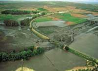
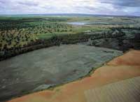
- Marisma: smooth zone that suffers overheating and drying according to the seasons. The marsh has been formed on limo imperial clay. The origin of the water is not only the rain, but also the rivers of the area, which carry the water in flood. The most important of the rivers is the Guadiamar, coming from the mine, which for a long time is directed to Guadalquivir, avoiding the natural channel, so the river Guadiamar only penetrates the marsh sporadically. These deviations have caused that the surface of the marsh and the thickness of water have diminished in recent years. Another important contribution of water is that of the stream La Rocina, with a small but sustained flow, which contributes what is necessary at the time of exhaustion. It is worth mentioning what the witnesses call caños: the mare was the channels created by the tide, then the passage of the flood waters of the rivers towards the marsh, and those that are almost in phase by the subsequent deviations. Among the measures recently adopted for the restoration of the marsh is that of facilitating the entry of the waters of the rivers to the marsh through these caños, something more than usual in recent years.
- Almost all the rest of the territory of the area of Doñana is covered by permeable sands of the Pliocene. In it are included the dunes. It is the recharge zone of the aquifer number 27, from where the rainwater feeds the low layers of water.In addition to rainwater, the surplus of the water used in agriculture is transformed into a recharge, contaminating the aquifer with fertilizers (mainly nitrates and pesticides). The behavior of the aquifer is different depending on whether or not it is located near the marsh. There the aquifer is free, but under the marsh it becomes semi-finished, forced by impermeable materials of the marsh. Here the aquifer feeds the marsh from bottom to top. Therefore, the contaminants introduced to the aquifer can make a long journey, perhaps years before they emerge slowly, there or here, through sands and smooth clays. However, not all the aquifer waters are concentrated in the marsh, since most of them run directly from the subsoil to the sea. Here pochis abound, always in zones of discharge of underground waters. The witnesses call eyes. These wetlands are included with their own scrub and cork oak. In this territory, where most of it is located outside the National Park but inside the parking lots, there are the anthropic activities: irrigated agriculture, several population centers, exploitation forests.
 R. R. Clothing and clothing Clothing
 - The link between the two previous zones is the so-called “ecotono”. Of scarce surface, but of great ecological importance, in which, being the nexus of union of sets of permeability very uneven, the underground waters emerge and maintain an aqueous and continuous environment, characterizing the ecosystem of Doñana. Another word widely used by locals is the lucios, that is, the stagnant areas formed in the depression, sometimes generated by surface and other underground waters. On the other hand, the lucios, caños or ojos have their own vocabulary rich to express concepts related to water, all of them have to do with the ecosystem of Doñana.
In summary, the area of Doñana needs two types of water to remain a water ecosystem, periodically provided by rivers and aquifers.
Condition of the flood of mine sludge
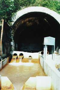
The open pit mine of Aznalcóllar extracts numerous types of sulphies to obtain lead, zinc, silver and copper. The sulphides are treated on the earth itself to separate what serves from what does not serve. The latter, an aqueous mud, is poured into a kind of reservoir, after previously passing through a scrubber mill. These wastewater are rich in toxic elements (As, Cd, Mn, Zn, Cu, Pb, Fe...) and acidic, that is, low pH, are harmful to the ecosystem.
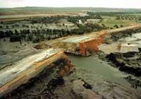
On April 25, Doñana suffered the worst disaster in recent years. For unclarified reasons, one of the walls of the reservoir raised crests and poured a dangerous 5 hm3 mud down the Guadiamar River towards Doñana.
Leaving aside the administrative and judicial problems, what consequences can this flood have in Doñana? His answers are very varied: he will not touch or touch him. Of course, some spoke, maliciously, of the National Park and of its short-term condition, avoiding the parking, aquifer, time and integrity of the ecosystem.
What conclusion do you have?
- The mud moves through the river, leaving the usual bed and overcoming the adjacent fields of cultivation with mud, which has caused a serious contamination of them. The succession is known: kill several animals and animals, lose the harvest of the years, destroy the food chain for many years. Socio-economic problems, besides ecological problems.
 We cannot understand the ecological risks that can exist in Doñana without knowing its "own" dynamics. Although the surrounding area of Doñana has undergone significant changes, it has taken advantage of the dynamics that correspond to it naturally so that the dumping mud can affect the area.R. R. Clothing and clothing Clothing
 - The mud does not seem to enter the National Park. In fact, shortly after the discharge, land barriers were raised so that the acidic waters diverted towards the Guadalquivir and from there they moved to the sea in specific areas of the river. Consequently, the acidic waters quickly reached the mouth and touched their fishing. Socio-economic problems also here.
- These barriers prevented the flow of the mud, depositing part of it in the bed. To help it, lime was introduced into the water, where when the pH is high heavy metals are precipitated. In this way, the water would move cleaner down and the mud held there would join more easily. Also mentioned was the installation of water treatment plants for subsequent discharge. However, all this must be done in haste before the rain arrives, since they fear so much that the rainwater is slightly acidic and would take the mud down the ground, perhaps overcoming barriers and penetrating to the marsh with pipes.
- The sludge of the fields begin to be collected using the excavator. The entire contaminated land cannot be excavated or transported immediately, remaining there for a long time awaiting the dissolution and burial of the sand of sludge, rainwater or river waters.
- The condition of the surface waters contaminated with the marshes depends on the previous performances to the rain. Underground water is very different. The toxic substances have already been introduced to the aquifer after the overflow of the riverside sludge: the samples collected so indicate. In addition, while it is a mud in the fields, a dilution can be produced and penetrate through the soil. On the other hand, conventional pumps can accelerate the movement of water in the aquifer.
- And a portion of contaminated water that is in operation before or after in the subsoil will reach several wetlands in Doñana (lucios, ojos). Will it then be serious? One knows with the data he has received so far. And it is that aquifers have the advantage that they partially reduce pollution and not any pollution. How many toxic has already entered? How much could be introduced in the dissolution of surface sludge?
A virus has been introduced in the heart of the Doñana ecosystem. It is about to determine what this accident might suppose was announced. Need for data, continuous monitoring. Waking up? It is said that there were numerous complaints about the poor condition of the reservoir. They were not taken seriously. A significant fact is that locals call the river Burning to the river Guadiamar, because periodically the water is burned; the discharges, despite being small, have been very common.
If you want to protect the Doñana National Park, you must also protect the environment. The reservoir of the mine, located on the banks of the river and on the banks of the Doñana river, is fundamental for the maintenance of the marsh. Who happens to him? It is not the same to place it here as in the Doñana basin or outside. The risk always exists, but this is much higher when there is a natural space that wants to protect a little further down. Only a matter of meaning.
Zu idazle
Zientzia aldizkaria

