

Where am I? latitude and longitude calculation
I woke up scared. The intense light hurt my eyes and prevented me from seeing the surroundings. Gradually I began to discover where I was: on a sandy island with only two palm trees. The last thing I remembered was what I left school and with my friends I went home. There was my school backpack, on that radiant stage, next to a bottle half-buried in the sand. As if I was the protagonist of a comic book, instead of wondering how I got to myself, I felt the need to know where I was. He was clear about the steps he had to take: knowing the location, writing on paper, putting the help message in the bottle, throwing it into the sea and waiting. Regardless of how absurd the situation was, I started working.
On my watch it was 22 and I saw the Sun rising to the left on the horizon. How was it possible?
For a more sustainable beginning of the course, I remembered that the professor of Natural Sciences gave us the notes of Astronomy. I turned to the backpack without wasting time. I studied the first image of these notes and the explanations I wrote there:
“When we look at the Sun, we will observe that it is moving east (on the left) to the west (to the right), while noon indicates the south. Movement is the same for all other stars, planets and even the Moon. What is observed is a consequence of the movement of the Earth around its axis in the opposite direction, that is, from west to east."
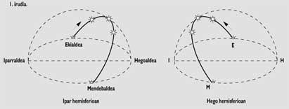
However, I saw a reverse motion that indicated to me that the Sun was observing “upside down.” In other words, I looked from the southern hemisphere. In fact, in this hemisphere, the Sun represents north at noon and therefore I mixed east and west in my first observation. It was certainly in the southern hemisphere!
After obtaining the first data from my location, I continued analyzing the notes:
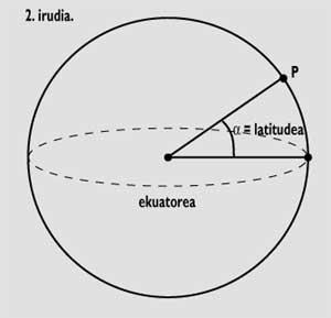
“The latitude at a point P above the Earth is the angle that forms the vertical of this point with the plane of the equator (Figure 2). Therefore, the latitude of the North Pole is 90º, that of the Basque Country 42º-43º and that of Ecuador 0º”.
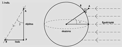
“A way of calculating latitude: in the autumn equinox (23 September) and in the spring equinox (21 March), solar rays attack perpendicularly in Ecuador (that is, at noon they do not produce shade). Since they are parallel to each other, if we measure the shadow caused by the solar rays in any other position, we could calculate our latitude” (Figure 3).
“The PA object will generate PB shadow when it is upright at point P, i.e. when the Sun is at the highest point of the horizon (i.e. at noon). By the object and the lengths of the shadow, we will calculate the angle b. Angles b and <unk> (latitude) are equal for trigonometric reasons.
tg < = shadow length / object length”
“Let’s start working,” I thought among myself. I took a pen and nailed the sand in a very soft place. “Too bad that there are no longer objects to make fewer mistakes. However, today, September 20, there are 3 days left for the autumn equinox. Hopefully, the two mistakes will be balanced.”
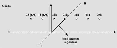
Every minute I started marking the places where the shadow came and got the following result (figure 4):
The smallest shadow (noon) occurred at 23 o'clock. I saw clearly that it was far from Euskal Herria. Leaving for later the analysis of this data, I have focused on the calculation of latitude.
Length of the shadow = 5.6 cm; of the
pen = 13 cm.
Therefore,
tg < = 5.6/13=0.43 and (less bad I had a calculator in the backpack!)
b = latitude = 23º 18’.
It was next to the tropic of Capricorn! (3).
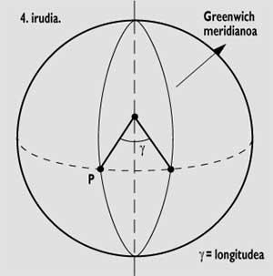
“The length at a point P above the Earth is the angle that forms the meridian of this point with the meridian of Greenwich (Figure 5). To the sites west of the Greenwich meridian is added W (West, abbreviation of the English West) and to those east E (East, east).”
“One way to calculate the length: If anywhere in Euskal Herria we measure and mark the shadows produced by a vertical object throughout the day, we will see that the shortest shade of winter occurs at 13 hours and minutes. This phenomenon occurs at 14 hours and minutes in summer, due to the advance of the official time regarding the solar time, which is one hour and 2 hours respectively. Considering that the meridian of Greenwich passes through Tarbe and Huesca, among other things, for when the Sun reaches Euskal Herria has a small "delay": 3-4 minutes in Zuberoa and 10 13 minutes in Bizkaia.
To calculate the length of a place west of the Greenwich meridian, we must take the time corresponding to the minimum shadow and calculate its delay with respect to noon (if we are to the east we should measure the progress).”
“As the Sun turns all day (360º):
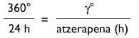
or in minutes:
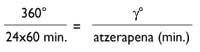
being gº the length”.
I based myself on the explanations of the notes to make my calculations. On the island noon occurred at 23 o'clock. This indicated the official summer time, so it should take two hours. Thus, noon occurred at 21 hours. In other words, he was 9 hours behind the Greenwich meridian. Therefore:
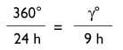
and from here
W = 135° W (West)
I reopened the backpack, left the atlas and started the frantic search for my position. In that position I found the Gambier islands of French Polynesia, near Mururo. A few kilometers from that atoll that perhaps has become so famous.
Without wasting time, I wrote the coordinates (23º 18’ S; 125º W) with the message of help that corresponded to him in a paper, I put them in the bottle and threw them to the sea with great force.
The first stars began to emerge, most unknown to me: there would be Alpha Centauri, the closest star to the Sun, the Big and Small Cloud of Magellan, and the galaxies closest to us... Suddenly, that is, deaf, deep and terrible. Scared, I opened my eyes and realized I was in my room. I have never known the reason for this apparent nightmare.
Zu idazle
Zientzia aldizkaria

