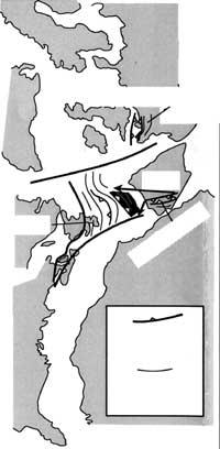
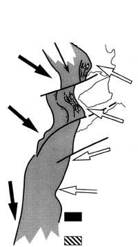
Location of the Iberian Peninsula between 600 and 300 million years

The theory of Plate Tectonics explains that continental masses have undergone major changes in their location throughout geological times. This means that the distribution of continents and oceans has not always been the same. What's more, the ocean bottom nowhere exceeds 200 million years. As for the continents, history is even more complex. In a nutshell, we can say that in the history of the Earth the continental masses have fractured and gathered again and again. In the last meeting the supercontinent called Pangea was formed. This began to divide 200 million years ago and the changes initiated have led to the current geographical situation. This long and complex history of change has been made possible by the work of geologists.
The use by geologists of various techniques (especially by comparing rocks and rock sequences in certain areas) is leading to the reconstruction of the stages of rupture and union of continental fragments that have taken place in the history of the planet. As is logical and as it happens in all other historical sciences, the older the facts that are wanted to investigate, the more difficult it is to study them. This is because in the last stages the previous tests have been diffused. Something similar occurs in archaeology. Historical times are known with quite precision, but in the case of Paleolithic there are more gaps of knowledge than probable facts.
Members of the Department of Geodynamics of the UPV-EHU, together with colleagues of the University of Badajoz in Extremadura, are investigating different areas related to the creation of the Iberian Peninsula. It is, above all, to study the situation existing at the end of the Proterozoic and beginning of the Paleozoic (600-500 million years) and the movements that have occurred during the 200 million years following the formation of the Hertziana mountain range.
So far we have been able to know that the Iberian peninsula was born in the western end of Africa. At this time the Cadomiana mountain range was formed when the arches island of the shore of the African continent collided with the continent. The footprints of the Cadomiana Mountain Range have been imprisoned in few places, such as in extensive Extremadura territories, although they are currently very eroded.

Later this territory was separated from the shore of Africa, creating a geological structure similar to that of Japan with Asia. After the volcanic arc a new small oceanic basin (Japan Sea) was formed, where huge amounts of sediments are accumulated. The extension of the new sea causes the rotation of the Iberian peninsula with the continental shore and the Extremadura territory with the peninsula. Subsequently (that is, for about 450 million years) the continental convergence begins and the Hertziana orogeny is formed, so widespread in the Iberian peninsula.
The objective of this study is to clarify the details of what happened between 550-450 million years. After the formation of the mountain range on the African coast, it broke and turned. Among the aspects analyzed are the peculiarities of volcanic rocks, autochthonous sediments and the evolution of life in the first steps of the history of this small continental section. The data obtained will allow us to have relevant information and, compared to the rocks of this age appeared in other territories, the original Cadomiana Mountain range can be reconstructed.
- Title of the project: Origin and evolution of sudibic pride (ZOM and ZCI) in the lower Paleozoic. Registration of magma, paleobiology and paleogeography.
- Objective:: Objective: Characterization of the sedimentary environment, characterization of the geochemical and isotope evolution of magmatism and elaboration of a geodynamic model.
- Financing: Financing: DGCYT
- Director: Luis Eguiluz Alarcón
- Research team: Rafael Ramón Lluch, Arturo Apraiz Atutxa, Teodoro Palacios Medrano and Alberto Bandres Martínez.
- Department: Geodynamics.
- Center: Center: Faculty of Sciences


