

Hydrometeorological network of Bizkaia
Currently, the hydrometeorological network of Bizkaia consists of 36 stations. However, before the end of 2005, four new stations will be launched in the Barbadun, Asua, Agüera and Altube rivers. And so by the end of the year there will be a total of 40 stations. In addition, Bizkaia has 16 other stations dependent on the Basque Government.
In hydrometeorological stations a continuous control is carried out that is recorded mechanically and digitally. Digital records are immediately transmitted to control centers. They are sent by radio or microwave, which allows to know the state of the rivers within a maximum of ten minutes.
To do this, the stations are distributed along the river basins forming hydrometeorological networks that have many objectives such as flood water monitoring, water resources management, analysis of the evolution of toxic waste, etc.
Types of stations
Four types of stations are distinguished: weather, flow, quality and hydrometeorological.
Meteorologists measure precipitation and air temperature. In total there are fifteen in Bizkaia. Rain gauges are used to measure rain. Inside these cylindrical devices rainwater is collected, which when they receive a certain amount of water, sends the signal to the device that registers it. Rainwater is also stored in a tank to check the recorded value.
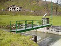
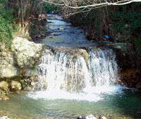
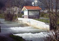
Capacity stations are located in the riverbed. River flow meters are used to calculate river flow. These devices enter the water and measure the speed of the current through the helix. The flow will be measured several times the speed of a certain stretch of the river to calculate the average speed of the entire river. By multiplying this average speed by the surface of the river, you can calculate the existing flow at that time.
However, it is difficult to measure the continuous flow of the river. It is easier to measure the height of the water sheet and then convert this level into flow, knowing the average speed and surface occupied by the water at each height. This level can be measured in the channel itself or in an annex well. The most common way to measure is by using a buoy in the well that goes up and down with the water layer.
Variations in water level over time are recorded in a device called a limnigraph. This registration can also be done electronically, which is valid for the transmission of the data received by radio, telephone or satellite. This way you can know the flow at every moment. This information is of great interest as it is applicable in many areas: biological, ecological, geological, hydraulic studies, etc.
On the other hand, in these seasons we can also analyze the physical-chemical characteristics of the water and some meteorological variables such as rain, temperature, humidity, wind speed and direction, solar radiation, etc.
Quality measurement stations observe other parameters such as pH, water temperature, conductivity, dissolved oxygen quantity, turbidity, organic matter and ammonia quantity.
The use of these variables allows to measure water quality and to know the approximate amount of pollution both urban and industrial. In this way, the sustainable measurement of this information and its transmission in real time to the control center allows detecting irregularities such as toxic emissions or pollutants.
Finally, in Bizkaia there are three hydrometeorological stations that measure water level, precipitation and air temperature.
The new stations will be capacity stations. These four stations are necessary to complete the hydrometeorological network of Bizkaia. In this way the flows, the amount of rain and the quality of the waters of the rivers of all the basins of Bizkaia can be controlled. In addition, improvements must be made to existing stations
Finally, in order to improve the hydrometeorological network, continuous measurements of the quality of river waters will be made, allowing all citizens to obtain this information through the Internet in real time.
Zu idazle
Zientzia aldizkaria

