

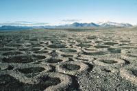
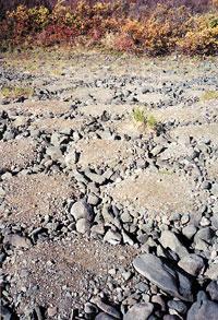
Ice playing with stones
Scientists have long known that these formations were not a compensation for the work of the elves or aliens; the explanation, of course, is much more terrestrial and has much to do with the climate and the type of soil. An explanation has been sought for each of the formations and now some scientists have presented a complete model that brings together all the agents. The study was conducted by American geologists Mark Kessler and Brad Werner and the results have been published in the journal Science.
These geologists have focused on the rock formations that appear in Alaska, some Norwegian islands and Alpine areas. They consider that at the origin of all the formations they command two main forces, depending on which is the strongest of the two, the stones will be organized in one way or another. In addition, there are other agents to take into account, just that in one of them there is a small change to move from one configuration to another.
With all these variables, a numerical model has been developed in which the results obtained by computer correspond to the formations that appear in nature. Therefore, the researchers have mathematically explained the rock formation lines. It seems that the model has explained what was previously known, that is, that the main mechanism is the cyclic processes of freezing and thawing, which causes movements in the soil able to move the stones.
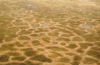
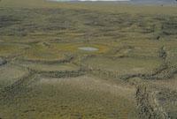
Witch wheel created by ice
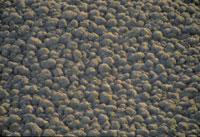
These curious stone formations arise from the division and arrangement of the soil and fine grain stones in soils between a decimeter and a meter deep. In principle, in these soils the stones and fine grains are mixed, with intermediate water. When ice crystals form, liquid water floats and expands the top layer. In addition, increased volume in water freezing also contributes to this expansion. Consequently, it destabilizes the interface between stones and soil.
In addition, on the ground the large stones are located at the top, while the smaller granules in the lower layers, because the fine grains go from the hollow of the stones down. However, the freezing and thawing processes that occur between these layers alter this structure. In fact, by freezing the soil, the isotherm drops from top to bottom and the top stones freeze faster than the fine grain soil, as the stones are dry. At the same time, the soil loses water, dries and compacts. In steep areas, this process requires moving stones and fine grains.
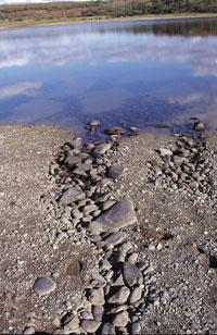
When melting ice, compacted soil reabsorbs water and expands. But as it expands vertically, it does not equal the lateral displacement that occurred before. As a result, the stones move upwards and towards the area of high concentration of rocks, while the soil moves downwards and towards a high concentration of soil. This process has been called as lateral classification, so that after successive cycles of freezing and melting stones and soil are separated.
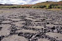
The second main mechanism is the alignment of the stones. The movements that occur during freezing and thawing cause the rocky areas to rise, while the soil is deeper.
In addition, the rocks are limited laterally. Due to the increase differential, the stones move from the thickest areas to the small ones, extending them on an axis. In the end they are aligned.
Depending on which of these two mechanisms is the most powerful, different types of formations are generated. However, other agents must be considered. The most important are the slope and the concentration of rocks in the soil, only a small modification occurs in one of its agents to move from one disposition to another.
From one constitution to another
In the computer model, all agents have been quantified and can see what happens by changing the value of the variables. This allows to visualize the influence of each variable in the creation of circles, labyrinths, islands, lines or polygons, as well as the changes necessary to move from one formation to another.
For example, if there is a formation of circles, it is enough to give a zero value to the force acting laterally and reduce the concentration of stones (to 1,000 stones/m2, for example) to explain a labyrinth. If the concentration of rocks is even lower, 700 stones/m2 or stone islands are obtained. On the contrary, if the concentration of stones is 100 stones/m 2, as the slope increases, the stone islands pass to the lines that descend on slope.
On the other hand, if the force acting laterally or the force that forces the stones to align is large, the stones go from being arranged in the form of an island to forming polygons.
This transit can also appear physically. On the one hand, the floor should be less compact and on the other, the stones should be large. Because between the large stones there are open spaces of cold air, the rocks that form them freeze quickly. Since it is not an excessively compact soil, the lateral classification mechanism is relatively weak, which generates instability in the depth of the rocky areas. Rapid freezing, however, increases lateral movement, tightens the rocky areas and forces them to stretch. Therefore, instead of the islands appearing, polygons are created.
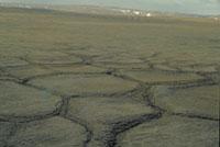
Polygons, more complex formations
The most complex dynamic is that which generates polygons. They are precisely due to the interaction of the two main mechanisms. Thanks to the computer model, they have demonstrated why and how one of the characteristics of these networks that are formed by joining polygons is explained. In fact, in the polygon meeting zones there are cutting points of three sides and the same angle, both in the computer and in nature.
According to geologists, when stones are ordered forming the smallest cutting angle, in the part of the soil delimited by these stones the movement that pushes them to tighten is weaker. Therefore, stones tend to organize the smallest cutting angle as generated. The cuts of four or five sides are unstable and form the three sides. Similar trend is observed in soap bubbles and magnetic fluid foams.
In short, geologists have verified that the phenomena that occur in nature coincide with those that appear on the computer. Therefore, from the point of view of stone formations, it is considered that clues can be guessed on the importance that each agent has had in its formation, as well as on the characteristics of the soil. Therefore, in addition to providing a complete explanation, this model can serve to know the properties of the soil.
Geological influence of cold in our latitudes What is presented in the article is an explanation of a research work carried out in high latitudes, but these results can also be extended to other latitudes if the conditions are adequate. In fact, the cold climate, the humid soil that freezes and freezes cyclically, and pebbles are the only elements necessary to generate the aforementioned geometric formations. Therefore, in some isolated areas of the Pyrenees, Sierra Nevada and the mountains of the Iberian Peninsula you can also see some of these formations. However, they are not particularly spectacular, since ice, both in the Pyrenees and in the rest of the mountains of Euskal Herria, has its greatest influence on the erosion of rocky areas. Consequently, in the areas of snow and ice accumulation the moraines have been formed, while in the rest of the areas the large gravels that accumulate at the feet of the cliffs are concentrated. Polygons, rings and others in high altitude regions, such as those of Gavarnie and Monte Perdido, can be seen in Aneto and the Pyrenees, generally undeveloped. Another thing is the question of quaternary glaciations, since they are then the geomorphological formations that are observed in our mountains. The most spectacular are paleomorries, since most of the others have been hidden by later accumulated soils or, in most cases, eroded long ago. You can still see the paleomorrenos in the Pyrenees, the area of Aralar, Anboto, etc. Our latitudes are silent witnesses of the present high latitudes. |
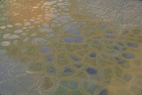
Without stones
Where there are no stones, polygons and other geological formations are also formed. For example, in clay soils good polygons are created, larger than those of stones. However, there is a difference: the center is not always up, but inward, so water can appear.
In all of them, at a depth of 30 to 50 cm from the surface, is the permafrost, icy soil.
Zu idazle
Zientzia aldizkaria

