

Ice relief moulder
This landscape dynamics is not limited only by external elements. Its morphology will depend on lithosphere (rock), hydrosphere (water), atmosphere (climate) and biological activity. Thus, depending on the combination of these factors, the relief will collect certain characteristics by developing unique landscapes. Along with this, one cannot ignore the human influence that, to a large extent, has produced a transformation of the morphology of the terrain and is being carried out.
Who could think that there were glaciers in our old Basque Country? It seems crazy, right? Schmidt-Thomé and Gómez de Llarena, in the 1940s, concluded that, following some tracks that had been “printed” on the nearby rocks.
As a result of World War II, the information received by these two scientists was lost and German scientist Karl-Otto Kopp tried in the 1960s to saturate his work.
The last glaciation in Europe lasted until about 25,000 years ago, when the highest mountain ranges in the Basque Country were covered with ice. In this article it is intended to explain the influence that the ice has had and continues to have on the relief.
Glaciations Glaciations
Glaciers are masses of mobile land ice. There was a time when the vast lands were covered and moulded by the ice, and now it is, although the covered surface was much smaller. Currently the permanent glaciers have a covered area of 15 million km2 (1.5 times the European surface), most of Antarctica (13 million km2) and
Greenland (1.65 million km2). The rest (3%) is very divided between Alaska, Canada, New Zealand and permanent snowfalls (Alps, Andes, Caucasus, Himalayas, Pyrenees…).
In areas where the climate is not so cold, in the temperate months below sustainable snow, the ice disappears reappearing in the coldest months. In these cases, although the relief is the ice itself, the landscape presents periglacias characteristics.
From the birth of the Earth to the present, many glaciations have happened. Chronologically speaking they would be:
- Gondwana Glaciation: about 2,300 million years ago. The traces of Canada are known.
- Infrared Glaciation II: about 950 million years ago.
- Infrared Glaciation I: between 825 and 740 million years ago. The tracks are in Australia.
- Eocambrica Glaciation: between 675 and 600 million years ago. They are located in Scandinavia, Australia, China, Brazil and Africa.
- Siluriar-Ordovicica glaciation: between 470 and 410 million years ago.
- Permocarbonífera Glaciation: between 340 and 255 million years ago.
- Cenozoic Glaciation: about 40 million years ago. Also called pleistocene.
The existing brands in Euskal Herria and the Pyrenees, however, correspond to the Glaciations of the Quaternary. In Europe and America four glaciations predominated, but several names are known and the duration is variable (see table 1).
Hypothesis on glaciations
More than sixty hypotheses have been proposed to explain these climatic “crises”. However, since their enumeration would be too long, only some of them will appear here:
- Glacigenic solar hypothesis:
- Theory of the stagnation of the gaseous diffusion: In the opinion of Öpike, the periodic diffusion of hydrogen from the solar surface is produced by the absorption of large amounts of energy over millions of years and the reduction of the radiation emitted by the Sun.
- Galactic theories: According to Steiner and Grillmaire (1973), the distribution of mass in the Milky Way causes the Sun to cross zones of “galactic forces”. This could hinder the diffusion of hydrogen in the solar center and affect radiation.
- Glaciogenic land hypothesis:
- Theory of orbital changes: The changes in the insolation time coincide with the temperature changes, with minimal insolations ahead of the thermal lows. This theory would serve to understand interglazal-glacial rotation and not to understand an interval of glaciations.
- Addition of heat emitted: The Earth's atmosphere lost enough CO2 and the Earth cooled enough to produce glaciations.
- Add albedo: The capacity of reflection of the Earth's solar rays is variable, conditioned by the increase of volcanic dust in the atmosphere, the increase of the intensity of the magnetic medium, the continental distribution with the geographical poles, the average height of the continents. These reasons could prevent sunlight from crossing the Earth's atmosphere by decreasing its temperature.
Types of glaciers
In relation to the glacial hypotheses mentioned above, the expansion of glaciers depends on two conditions: the feeding (amount of snow that receives the glacier) and the ablation (fusion and evaporation of the snow received). The relationship between the two is called “glacial balance” and the glacier only advances when the first is greater than the second.
Observing the masses of ice currently distributed throughout the world, glaciers of various sizes and shapes can be observed, among which a specific classification can be made:
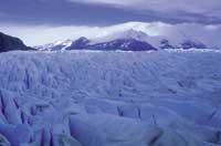
The inlandiss are extensive ice masses developed in regions where the climate is very cold and the ablation is very low. The diet is also low, since rainfall is not abundant. The ice coating can reach 2,000 meters thick and sometimes you can see the highest levels of the topographic base outside the ice as if they were rock ghosts. Antarctica would be the best example.
The ice caps have a smaller surface and the canvases are extracted in all directions. They abound in high latitudes like Alaska.
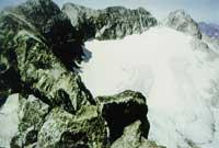
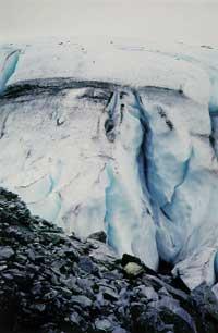
The mountain glaciers are masses of ice located above the perennial snow in the highest mountains. In the Pyrenees the limit of the perennial snow is located in 3,200 meters, above which the snow accumulates in the circuses, transforming the snow from the bottom into ice. In summer, in shady areas where solar rays do not reach more than 2,500 meters, you can observe persistent snow masses that can take the properties of glaciers, which are fridges. The closest examples are found in the Pyrenees and Alps (see photo 1).
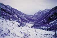
The valley glaciers appear as a dendritic network. The tabs coming from the upper circuses are joined down forming a single tongue. Despite the disappearance of this type of glaciers in the Pyrenees, you can see numerous glacial valleys modelled by themselves (see figure 2).
Main glacial morphologies
It is clear that the first snow that will form the glacier cannot accumulate everywhere, since in the bare walls the snow would fall by gravity. Thus, often, these red peaks surrounding these glacial morphologies are called nunatas (Nu). The snow needs areas not very inclined to accumulate and compacting on them and produce ice. With the passage of time, in addition, the ice itself will adapt these places with shapes in tonel due to erosion.
The circuses (Zi) are the main feeding areas of the glacier. From there, the ice tongue will form, in most cases, an extensive valley glacier (Hg) in the form of U, leaving hints of its erosive capacity in the whole environment. There are, however, valley glaciers in the form of V that can be due to subglacial avenues, that is, to floods of the rivers of thaw that run under the ice tongue. In high mountain ranges it is frequent to observe the forms produced by the glaciations. Consequently, So would be the tipping surface between a valley affected by an older glaciation and the main valley. In the same way, the hanging valleys (He) could be created in an older ice age. However, it is possible that these hanging valleys are linked to a high circus and from there the ice reeds feed the main valley.
Unique structures affected by glaciers
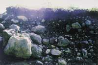
The ability of ice to break the surrounding rock and transport fragments is enormous, even more so if it is an ice spike of about hundreds of meters of depth and a few kilometers of length. These rock blocks are totally heterometric and can be placed in any position of the ice tongue: on the surface, in the background, in the edges or in the center of the ice mass. Sometimes these rocks have the fully covered surface of the glacier and the ice is not visible. These rocks are moraines (see Photo 4) and, like ice, confer special characteristics to the substrate in contact, forming stretch marks in the erosion.
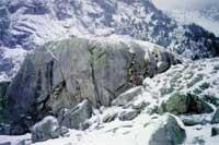
On other occasions, the ice itself can shape the heterogeneity of the lower substrate by applying sheep shaped rocks (photos 5 and 6). Since the path that follows the mass of ice suffers numerous fluctuations, it loses energy to overcome these glaciers, so some of the rock blocks that it carries inside accumulate in the background and the ice that comes behind molds forming structures called drumlin.
Due to climate change, the temperature of the Earth has increased and many glaciers have receded, leaving the moraines (see photo 7) and discovering the stretch marks generated. When the glacier disappears, the presence of moraines transported by the tongue in its front or of “front moraines”, allows to know to what extent the language of ice expanded. In turn, the observation of stretch marks, rocks in the form of sheep and drummers allows to deduce the direction and direction of the glacier movement.
Remains of the glaciarism of the Quaternary in Aralar
In the middle of the century, unique structures caused by ice were discovered in Aralar. Due to the wide configuration of some valleys, their unique structures and the moraines discovered in the ravine of Arritzaga, the surrounding mountain led him to think that some ice of the Quaternary had influenced.
The ravine of Arritzaga, with direction NW-SE, is the shortest way to ascend to the shelter of Igaratza from Amezketa and is located northeast of Mount Txindoki. Los Sres. Gómez de Llarena, Schmidt and Kopp concluded, through their investigations in these areas:
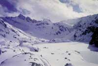
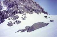
In Würma (Figure 2), the limit of the perennial snow was 1,050 meters and a glacier of 4–5 km in length was found at a height of 800 meters the extreme moraines located in the ravine of Arritzaga. The glacier was about 100 meters thick and could reach 200 meters wide. The circus would be located between the Ganbo and Irumugarrieta mountains. About 100 meters below the copper mine, below the place where the extreme moraine is located (see photo 8), the valley, initially quite wide, loses its form of “U” and adopts the form of “V”. The end of the glacier developed to the place where the moraines are located and its limestone end prevented it from thriving. At this point the ice melted and over time the water developed a ravine in the form of “V” (see figure 10).
The ice may have left other tracks, but if so, the subsequent karstification has removed all. Further northwest, near Azkarate, a 1,700 metre long glacier left another moraine.
Periglaciarism
In the periglacial systems the ice has an important influence during a good part of the year, but not continuously. In addition, it is not only attached to a medium and, conditioned by the vegetation, has many intensities. Periglaciarism is today concentrated in 16.5% of the total surface of the emergent land.
Some concepts
As with glaciarism, concrete processes are given in the periglacial systems, which give rise to particular forms. Below are some of them.
- Pipkrake: The lower humidity of the grains on the ground is transformed into a thin ice stick as the temperature drops, raising the grains a few centimeters. When the temperature rises and melts the ice, the grain falls a few centimeters (see figure 3).
- Ice lentils: Soil water can be frozen by forming layers or lentils parallel to the surface. Around the Polar Circle persist throughout the year.
- Ice cubes: By transforming the humidity of small fractures into ice, the volume increases by increasing the fracture and breaking the rock (gelivation).
- Solifluxio: In areas where the ice is persistent, the ice next to the surface of the mass of ice melts in summer and cannot be filtered through the icy lower wall, forming a muddy mass saturated with water that begins to move slowly.
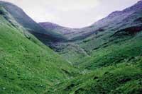 Photo 9. The valley is quite wide at the top and has a "U" shape. It is observed that below it is tightened in the form of "V" due to the erosion caused by the fusion water that was passing under the ice mass.I. Muguerza muguerza
 - Cryoturation: It is any change in the original state of the ice affected layers.
- Litee Grëzes: They have also been called stratified amiluzamientos. It is simply the transport of the pipcraquea, gravity and rock blocks affected by a layer of clay located at the bottom.
Cold and periglacial processes in Euskal Herria
Although in the Basque Country Liteese grëzes have been found, remains of solifluxio, signs of gelivation and cryoturbation forms, are not very abundant. Therefore, they have always been considered unforeseen and have never been properly analyzed. It is interesting, however, that some of these examples have been found in caves. This could lead to problems or contradictions with the way to explain the traces of cold processes on the surface.
All the tracks observed appear from Quaternario. The oldest remains are cryoclastic blocks found in the cave of Lezetxiki (Arrasate-Mondragón), that is, the accumulation of angular rocks generated by the break of rocks by hard frosts. As a result of the investigations, it has been concluded that these deposits were accumulated in two phases, the first corresponding to the glaciation of Würm and the second to the retraction postwürmiana.
The periglacial processes occurred around the glacial masses, whose upper limit was located below the lower limit of the permanent snow. According to the researchers, the Quaternary ice reached very low levels, with the limit of the perpetual snow of Würmiar in 650 meters. Therefore, if you want to find periglacial structures of the time, you must search below that limit.
In the caves of Xalbador (Zumaia) and Igitegi (Oñati) cryoturbations have been found that have affected the alluvial deposits accumulated in the karst ducts and this discovery indicates that at this time of the Quaternary there would be much cold.
Why have not appeared on surface the periglaciary remains that have appeared in the caves?
The non-existence of these cryoturing structures does not mean, however, that they were not created. It may have been destroyed by transportation and erosion of detritic materials. The accumulation of sediments type “grëzes liteés” between Oñati and the sanctuary of Arantzazu has shown the lithological control of these cryoclastic deposits. They are some of the coldest brands and require large freeze-fusion cycles for their formation.
The remains of the gelifraction are found on the cliffs of Aloñamendi (Oñati). The colluvial materials detached by the ice itself can be seen dispersed.
The areas affected by tectonics retain their origins in diaclae and fractures. In Atxarte are the cliffs, in the form of meadows, not consolidated, and shortened. It is clear, moreover, that the origin of the new glitches is largely due to tectonics and not to ice.
In our territory we have found remains of two types of solifluxios: cold and temperate. The genetic separation of these two types of solifluxio is usually quite difficult, especially when it is not possible to separate them through sedimentary processes. In the Basque Country, colades of cold origin have a minimum thickness of centimeters. In the cave of Igitegi (Oñati) appear solifluid-like materials, but its great thickness questions the Periglacian origin.
It seems that the cold ones that affected Euskal Herria were not excessively violent, they influenced very punctually and only in short periods of time. It is deduced from the appearance of a small variety of structures. In addition, solifluxio flows do not serve to demonstrate the existence of a periglaciar domain.
| In Europe | Time (year) | In America | Time (year) |
GUNZ Gunz-Mindel | 75.000 | NEBRASKA Afton | 200,000 |
MINDEL Mindel-Riss | 300.000 € € 300.000 € | KANSAS Yarmouth | 300.000 € € 300.000 € |
RISS Riss-Würm | 75.000 | ILLINOIS Sargamar | 120,000 |
WÜRM PostWürm | 25,000 | WISCONSIN PostWisconsin | 25,000 |
Zu idazle
Zientzia aldizkaria

