Radar of the wind
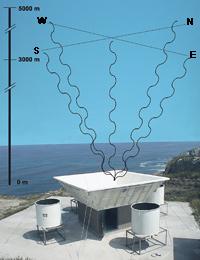
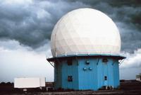
The Climate and Meteorology Service of the Basque Government has a very special radar to know, predict and analyze the evolution of violent climatic episodes: the profiling radar, which makes vertical profiles of horizontal wind. Located in Cape Galea, in Getxo, Bizkaia, it shows the profile of the winds that circulate on it at an altitude of up to 3,000 meters, that is, it determines its direction and speed.
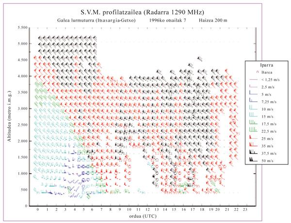
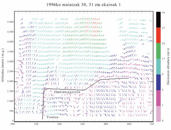
As an example, on February 7, 1996, a deep depression caused a strong wind in the shape of a shed, with even blowers of 125 km/h. Conventional radars cannot record such events, but through the profiling radar it was seen very well how the front wind approached the coast, and how that front in altitude descended from top to bottom, and how at 7 in the morning it reached the level of the earth.
To achieve this, the profiling radar emits microwave, is directional and measures the wind, that is, something that is not solid or liquid. However, conventional radars, the most used in roads, airports or climatology, provide information about the presence of objects through directional or non-directional radio waves.
Exploring vertical
The galea is a rare profiling radar located in the cape, not only for its appearance. In fact, to get wind data, the radar antenna emits microwave pulses into the sky of 1,290 MHz in five directions. A pulse is sent vertically, directly to the zenith, and the other four cardinal points, with an angle of 15.5º. It sends pulses of 700 and 1,400 x 10 -9 seconds of duration.
The radar takes advantage of the variation of the refractive index. In fact, refraction occurs between two means: the waves, when passing from one to the other, change direction. The clearest example occurs when a stick is immersed in water; in the area that crosses the surface it seems that the stick twists because the direction of the light waves changes when passing from one medium to another.
In the atmosphere there are no changes in the environment, but the wind causes changes in the refractive index. This, in turn, causes some of these microwave emitted by the radar to be reflected and returned to the antenna. However, the frequency of the microwave returning is not the same as the frequency of the emitted ones, so they are used to obtain the results: the frequency difference of the waves emitted and the recovered ones is collected by the computer, treated and represented the profile of the wind with a precise direction and speed. However, the interpretation and conclusions of these images and data are the work of experts.
Normally, with the radar of the Galea a wind of up to 3.000 meters of height is measured, but it varies according to the conditions, especially of the humidity. On very little humid days it can reach up to 5,000 meters of altitude. The resolution is 100-200 meters, although it currently works in a resolution of 100%.
But besides measuring the wind, the radar measures the temperature. For this purpose, on the one hand, the waves collected by the radar and, on the other, the acoustic signals emitted specifically for it, collecting its reflection. Four claxons around the radar emit sound pulses of 300-400 nanoseconds, measured at an altitude of between 700 and 1,000 meters.
The range of the sound waves is lower than that of the microwave, so the measurements are made at a lower altitude. In addition, temperature measurements can only be performed during the day. In fact, when the radar was installed there was no house nearby, but today yes, so they can not be used at night. Wind measurements are performed every 25 minutes with radars and temperature every 30 minutes.
Multiple uses of data
All radar data are collected in the Directorate of Climate and Meteorology of the Basque Government. However, they have also been received at the School of Engineering of the University of the Basque Country, in the Atmospheric Environment Group.
The collected data are very versatile. According to Lucio Alonso, of the School of Engineering, the data are used for the investigation of the lower part of the atmosphere and for his meteorological studies: evolution of the wind and temperature, formation of layers of air, interactions between the wind and the topography, dispersion of atmospheric pollutants, study of extreme meteorological phenomena…
In turn, these research or studies have multiple applications. They can be used to predict and analyze short-term weather, especially when it comes to a stormy or intense rains. The data are also of interest to weather surveillance services at airports. Wind shorts are very dangerous for landing or take-off, and profiling radars are easily detectable.
It is also of great interest to environmental surveillance services, since the data can be used to predict the dispersion of contaminants produced by accident or by normal human activity. In short, atmospheric pollutants are transported by the wind.
Ozone from Brittany to Bilbao
The Atmospheric Environment group of the School of Engineering has carried out, among others, studies on the transport of ozone at a long distance.
For example, it is known that since 1989 ozone bags are generated over Bilbao, but the concentration of these bags is greater than that caused by the ozone produced in Bilbao. In Bilbao it accumulates, therefore, ozone from somewhere.
The combination of the data obtained through the radar profiler and the models of transport and meteorological trajectory obtained by other methods has shown that ozone is transported at a long distance at high altitudes. Thus they have known, in certain weather conditions, that the ozone measured in the Basque Country is the one coming from Brittany, in addition to the one produced in it.
The ozone coming from Brittany makes two routes before arriving to Bilbao: one is the current of air that comes directly from Brittany and the other, which after passing through the south of France and Tarragona, enters by the valley of the Ebro. In both zones, in addition, the amount of ozone is increased. However, just as the external ozone reaches Bilbao, the ozone created in Bilbao extends to other places.
It should be noted that when ozone is in the upper layers of the atmosphere, it helps protect us from solar radiation, but in the lower layers of the atmosphere it is toxic and the inhalation of many ozone affects us. It is very important to know this transport.
For the moment, there are about 12 radars of this type in all Europe, but Lucio Alonso is expected to grow gradually, especially considering the availability of airports and industry in areas with a lot of pollutants.
What is the radar?
Acronym for radio detection and ranging in English, that is, detection and location by radio. It is a tool and a system that calculates the position and distance of an object emitting radio waves.
In fact, the radar is based on the emission of short and narrow pulses of electromagnetic waves and their integration into a receiver after being reflected in an obstacle. Taking into account that the waves travel at a speed of 300,000 km/s, it allows to measure the exact distance to the obstacle. In addition, if the object is moving relative to the wave source, the speed of the object can also be measured by changing the frequency that occurs as a result of the Doppler effect.
Marconi laid out in 1922 the theoretical bases for the development of radar. During World War II it was especially important in the detection of German aircraft. Since then, aerial, terrestrial and maritime surveillance radars of military use have been developed and have become indispensable. Civil uses have also been multiplied: radars are used to control air traffic, measure the speed of the road, follow the satellites or waste of space, follow with precision the storms in meteorology, find buried objects… A type of radar is also used to automatically open the doors of the shops.
The radar identifies any object, because radio waves are reflected in mountains, bridges, buildings, streetlights or anything else. This can be a problem at an airport or at a speed control of the road, but in these cases the signal is filtered back. In speed controls, for example, it only identifies the waves that the Doppler effect has transformed and not the immobile objects.
Marine sonar is very similar to radar, but uses sound waves instead of radio waves, for its best reach under water.
From the world to BilbaoStudies carried out with the profiling radar have shown that the ozone produced in Brittany and the United Kingdom is transported in high layers of the atmosphere, reaching Bilbao, among other things. 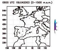 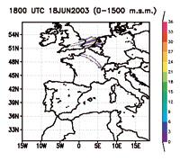 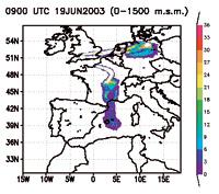 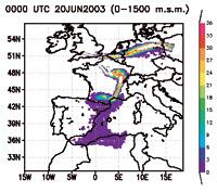 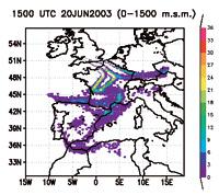 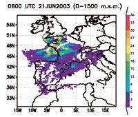 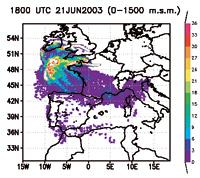 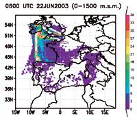 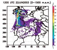 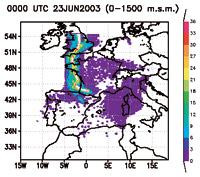 |
Zu idazle
Zientzia aldizkaria