

Google Earth to follow carbon dioxide
Text created by automatic translator Elia and has not been subsequently revised by translators. Elia Elhuyar
Google Earth to follow carbon dioxide
01/12/2009 | Elhuyar
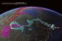
(Photo: Tyler Erickson and Google Earth)
Google Earth is an ideal application for researchers studying the concentration of carbon dioxide. For example, at the University of Michigan they have developed a very complex model to explain how carbon dioxide is introduced and extracted into the atmosphere over time. All these data have shown that Google Earth is the most effective tool to explain them graphically.
1.
259
2009
Description
008
Environment; Computing
News
Services
Zu idazle
Zientzia aldizkaria

