Oldest geological map
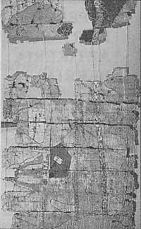
Amennakhte, the Fourth Ramses of Egypto, wrote in the times of the great pharaoh and it seems that he was the author of the oldest known geological map. Two researchers from the University of Toledo (Ohio) USA consider this scribe. The map made in 1150 directly reflects reality.
The map is a roll of papyrus 40 cm wide and 180 cm long. It was discovered in 1820 near the Valley of the Kings of Egypo. He has subsequently remained in the Egyptian Museum of Turin.
James A. Harrel and V. Max Brown has been the first geologist who has analyzed the map and who has compared reality to what was indicated on the map. Wadi Hammamat's rock formations explain in detail its shape and color.
It is little to say that the work done by the scribe Ammenakhte anticipated his time, if we consider that the next known geological map is from the years 1740.
Zu idazle
Zientzia aldizkaria