

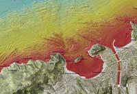
Donostia and Bilbao seabed in detail
AZTI-Tecnalia elaborates high precision cartographies
AZTI-Tecnalia presented the high-precision mapping of the seabed in the areas of Donostia and Bilbao. This mapping describes more accurately than ever the seabed of these areas. The material presented is part of the mapping project of the entire continental shelf facing the Basque coast.
A multibeam echo sounder has been used to achieve this precision. "This echo sounder emits 256 signals in a single pulse—the normal probes emit a single signal," explains Ibon Galparsoro, a researcher at AZTI-Tecnalia. "This technique allows us to study a wide field of research with a single pulse," he adds. In addition to exhaustive, it is fast. "When he sends a pulse and arrives he emits another. In shallow depth it has come to emit 40 pulses per second. This means that it has come to offer 10,240 data per second," explains Galparsoro.
In addition, the characteristics of the signal indicate the physical characteristics of the seabed. For example, in the rocks the signal is measured very clean and is very intense. In fine sediments, sludge, etc., the signal penetrates the seabed and the signal reaches the ship with less intensity. "This system has a small limit. It can reach 100 meters. From there the signal is lost," said Galparsoro.
However, knowledge of the characteristics of the seabed is essential to know and foresee the distribution of habitats. On the other hand, current legislation requires a morphological characterization of the seabed and habitats in order to adopt the necessary measures for their protection and management.
Zu idazle
Zientzia aldizkaria

