Wind where, energy there
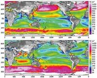
Oceanic wind data have developed a map that can help determine where to place wind turbines. For the map, researchers at the California JPL laboratory have used data obtained from NASA's QuikScat satellite for eight years.
Since its launch in 1999, QuikScat measures the speed, direction and strength of the surface winds of oceans around the world. These data serve to forecast storms and improve weather forecast models. Now they want to use this data to know the most suitable places to transform the wind force into electricity.
In addition, the technology needed to take advantage of ocean winds is developed. Moreover, some of these parks are already underway and, according to JPL researchers, are better than those on land, on the one hand because ocean winds are stronger and more stable than those on land, and on the other, because they generate less environmental impact.
Zu idazle
Zientzia aldizkaria